Twentynine Palms, California
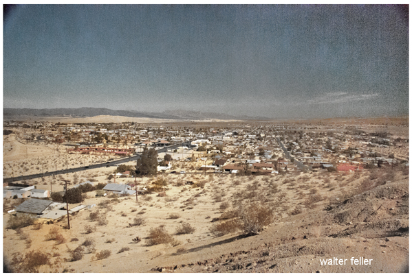
Population - 26,126
Elevation - 1,965 ft.
Twentynine Palms was an active mining community as early as 1870. In the 1890s a Mr. Aldridge built an adobe house here and and it was used by stage lines running between Amboy and Indio. After decades as a rest stop for wagon travelers on what was called the Utah Trail after a group of Mormons, the town was established in 1920. The post office was established on 28 October 1927. After WWI the government sent veterans who were suffering from lung damage caused by poisonous gas here to recuperate (Dr. Luckie). The climate and clear air worked their wonders - over 90% of them recovered. Later the name was changed to Twentynine Palms Springs, then changed back in 1927. In the 1870s and 1880s it was often called Palm City. Also known as 29 Palms. In 1950 the population was 1,022 and in 2000 it was 14,764.
(from - Mojave Desert Dictionary, Patricia A. Schoffstall - Mojave River Valley Museum)
Historic Twentynine Palms Photos
29 Palms - Dale Dry Lake - Mojave DesertDale dry lake east of 29 Palms is a small playa with a gravel surface. Also see: Dry Lake/Playa Formation ...
Oasis of Mara
The medicine man instructed them to plant a palm tree each time a boy was born. In the first year, the Serrano planted 29 palm trees at the oasis. ...
Morongo Basin, CA
Marine Corps Air Ground Combat Center Twentynine Palms Wonder Valley Yucca Valley The basin stretches approximately from the Interstate 10 in the south to ...
49 Palms Oasis
Parking area at end of Canyon Road, 4 miles west of Twentynine Palms off Hwy 62. Description: Several stands of fan palms, evidence of past fires, ...
Joshua Tree California
61325 Twentynine Palms Highway PO Box 600. Joshua Tree, California 92252 ... 29 Palms, CA � Mojave Desert Weather Click for Joshua Tree, California Forecast ...
Weather Data - Mojave Preserve - California Mojave Desert
Location, Needles FAA, Palm Springs, Palmdale, Parker Reservoir, Randsburg, Thermal FAA. Twentynine Palms. Latitude, N34-46, N33-49, N34-35, N34-17, N35-22 ...
Landers California photo tour - Joshua Tree Region
Yucca Valley, Landers, Twentynine Palms, Joshua Tree, Morongo Valley ... yucca valley, twentynine palms, lander, flamingo hills, joshua tree national ...
Hiking Trails
49 Palms Oasis. 3 miles - hiking time: 2-3 hours. Starting point > Parking area at end of Canyon Road, 4 miles west of Twentynine Palms off Hwy 62. ...
Indian Cove - Joshua Tree
Indian Cove is located 13 miles east of Joshua Tree Village and 10 miles west of Twentynine Palms on the north side of the Wonderland of Rocks. ...
Cadiz Dunes Wilderness
ACCESS: Travel 62 miles east of Twentynine Palms on State Highway 62. Turn north and follow the graveled Cadiz Road for 26 miles. ...
Sheephole Valley Wilderness
ACCESS: To access this wilderness, travel approximately 20 miles east of Twentynine Palms, California on State Route 62. The wilderness boundary is just ...
Fault Zones in Joshua Tree
The Oasis of Mara at the visitor center in Twentynine Palms marks the Pinto Mountain fault. The park has four other fault-caused oases that support the ...
Desert Ecosystem
As you go from Twentynine Palms to the South Entrance, you begin to see Joshua trees at the 3000-foot elevation level. Joshua trees indicate the Mojave ...
Joshua Tree National Park Back Roads
Leaving the basin, the road climbs a steep hill, then crosses the park boundary. The road leads to State Hwy 62, 15 miles east of Twentynine Palms. ...
Nature Trails
West of Indian Cove Campground. Keys View - .25 mile loop. Keys View Oasis of Mara - .5 mile loop. Oasis Visitor Center, Twentynine Palms. ...
Bristol dry lake - Cadiz Valley - Mojave Desert, Route 66
Chloride extraction takes place along the highway running south across the lake to Twentynine Palms and Joshua Tree National Park. ...
New Dale Ghost Town
New Dale ghost town, Twentynine Palms CA. ... Ghost Towns > New Dale < Twentynine Palms, CA - South Mojave Desert � Desert Gazette ...
Cleghorn Lakes Wilderness
LOCATION: San Bernardino County; 16 miles northeast of Twentynine Palms, California NATURAL RESOURCES: Named for the dry lakes found near its center, ...
Big Morongo
From Interstate 10 northwest of Palm Springs, take Highway 62, the "Twentynine Palms Highway." About 10.5 miles north on Highway 62, turn right on East ...
Johnson Valley Off-Highway Vehicle Area
The eastern boundary is shared with the Twentynine Palms Marine Air-Ground Combat Center. DO NOT enter this area. Johnson Valley offers a riding opportunity ...
Map of Sheephole Valley Wilderness
ACCESS: To access this wilderness, travel approximately 20 miles east of Twentynine Palms, California on State Route 62. The wilderness boundary is just ...
Highway 62
Twentynine Palms � Old Dale. Rice. Vidal Junction. Colorado River. Parker. Map of State Route 62. features - ecology: wildlife - plants - places - region ... TWENTYNINE PALMS
The first discoveries in the Twentynine Palms area were made by Dave Gowen and Joseph Voshay. The San Bernardino Guardian on November 29, 1873, ...
Chemehuevis at Twentynine Palms
The Chemehuevis had lived at the oasis of Twentynine Palms many times before the 1860s, as had other Indian groups. "Serranos had previously inhabited the ...
Chemehuevi - The Establishment of the Reservation
The Chemehuevi at Twentynine Palms for many years were never mentioned in .... From the point of view of the Twenty-nine Palms people now, as expressed by ...
Fan Palm Oasis - Desert Habitats
The Chemehuevis had lived at the oasis of Twentynine Palms many times before ... The water at the oasis permitted them to garden, and the surrounding area . ...
Chemehuevi Reservation Affairs
Although the members of the band for whom the Twenty-nine Palms reservation was set aside retained their identity as a group separate from the Chemehuevi ...
Palm Oasis Wildlife Habitats
At Twentynine Palms, mean temperatures for June through September range from 28 to 32 C (82 to 90 F). On only 29 days of the year does the temperature drop ...
Serrano - Religion, World View
Ramon speaks of an earlier time, when the ceremonial leader of the Serranos at Twentynine Palms, having no ceremonial house, came to Mission Creek to hold a ...
Cahuilla Indians of the southern Mojave Desert
The descendants of the Cahuilla who once lived at Twentynine Palms have scattered, but many of them are enrolled at Morongo Reservation, ...
Mojave Desert Mining History - Includes additional northern areas
The first discoveries in the Twentynine Palms area were made by Dave Gowen and Joseph Voshay. ... Panamint Another product of the search for the Lost ...
Serrano Indians - Oral History
They call it 'Twentynine Palms' nowadays. That was their place of origin, ... I still know that Twentynine Palms was the territory of the Mamaytam. ...
Chemehuevi History - American Period
Inasmuch as the Twentynine Palms area was relatively isolated, we do not know whether Chemehuevis occupied any sites there before the later years of the ...
Cahuilla Indians of the southern Mojave Desert
Clara True, the Indian agent who was most interested in the Twentynine Palms Reservation, had her main office at Morongo, from which she traveled by buggy ...
Cahuilla Indians
In 1874 gold and silver was discovered in the vicinity of Twentynine Palms, bringing it about that numerous ... Reservations ...
Mojave Desert - Bill Keys
In 1910, Keys arrived in the Twentynine Palms area where he began working at the Desert Queen Mine as custodian and assayer (one who analyzes ore and judges ...
Mojave Indian History - Mining
As noted in our discussion of Chemehuevi history, it was at this time that Chemehuevi began to settle at Twentynine Palms and in the Coachella Valley ...
Chemehuevi Indians of the Mojave Desert
In 1867 after a war with the Mohave, the Chemehuevi, moved westward toward the Twentynine Palms area shared the Oasis of Mara with the Serrano. ...
Serrano History - Mission Period
... the oral history account that tells us that the Maringo Serrano were the original inhabitants of the village of Mara at the oasis of Twentynine Palms. ...
Chemehuevi Indians - Sources & Resources
... the Office of Indian Affairs, provide information about the Chemehuevi at the Twentynine Palms Indian Reservation, the Chemehuevi Indian Reservation, ...
Peak Blooming Periods for Desert Wildflowers
Best areas: Along Twentynine Palms Hwy, Old Woman Springs Rd. Dominant Species: encelia, poppies, blazing star, yucca, joshua tree. ...
Joshua tree Habitat
Yucca Brevifolia Joshua Tree Chamber of Commerce 61325 Twentynine Palms Highway PO Box 600 Joshua Tree, California 92252 760-366-3723 . ...
Cahuilla Indians of the southern Mojave Desert
In 1874 gold and silver was discovered in the vicinity of Twentynine Palms, bringing it about that numerous prospectors procured themselves mining outfits ...
What and Where is the Mojave Desert?
Regionally, the southwest portions, the Antelope Valley, the Victor Valley, the Lucerne Valley and the Yucca Valley / Twentynine Palms areas are refered to ...
San Bernardino County Mining History
Twentynine Palms � Dry Lake & Vicinity � Ord Mountains � Fry Mountains � Oro Grande � Silver Mountain � Northwest San Bernardino County ...
Helen Hunt Jackson
Like others who reported on visits to the Indians of the area, they made no mention in their report of the Chemehuevis at Twentynine Palms. ...
Railroads of the Mojave Desert
Chemehuevis at Twentynine Palms The situation became especially desperate for the Indians when the Southern Pacific Railroad Company, which had been granted ...
Chemehuevi Ethnology and Ethnohistory
Chemehuevis at Twentynine Palms � The Establishment of the Reservation � The Willie Boy Story � Reservation Affairs � Recent Years � Major Sources ...
Southern Pacific Railroad
Chemehuevis at Twentynine Palms The situation became especially desperate for the Indians when the Southern Pacific Railroad Company, which had been granted ...
Twentynine Palms Weather
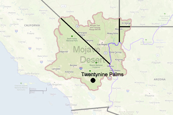
Twentynine Palms is a city in San Bernardino County, California. It is situated in the Mojave Desert, the gateway to Joshua Tree National Park. With a population of approximately 26,000 residents, Twentynine Palms offers an exceptional blend of natural beauty, outdoor recreation, and a military presence.
One of the main attractions in Twentynine Palms is Joshua Tree National Park. The park has over 790,000 acres and is famous for its unique Joshua trees, rugged rock formations, and diverse wildlife. Visitors can enjoy hiking, camping, rock climbing, and stargazing in this picturesque desert landscape.
Aside from its natural beauty, Twentynine Palms is also home to the Marine Corps Air and Ground Combat Center. This is the largest Marine Corps base in the world. The base is vital to training Marines for combat readiness and integral to the city's identity.
The city of Twentynine Palms provides a range of amenities and services to its residents and visitors. It has a variety of shops, restaurants, and accommodations to cater to different tastes and preferences. The city also hosts various events and festivals throughout the year, such as the Pioneer Days celebration and the Street Fair.
For outdoor enthusiasts, Twentynine Palms offers numerous recreational activities. Nearby Joshua Tree National Park is a haven for hikers, climbers, and nature lovers. Visitors can explore the park's many trails, rock climb the famous Joshua Tree rock formations, or relax and enjoy stunning desert vistas.
In conclusion, Twentynine Palms, California, is a city that offers a unique blend of natural beauty, military presence, and recreational opportunities. Whether you are looking to explore the vast landscapes of Joshua Tree National Park or experience the rich military history of the Marine Corps base, Twentynine Palms has something to offer for everyone.
