Death Valley Geology Overview
Death Valley was once covered by shallow seas that left behind layers of limestone and sandstone. Over millions of years, powerful forces inside the Earth folded the land, raised mountains, and drained the sea. Later, the land stretched and cracked, forming valleys like Death Valley. Volcanic eruptions added colorful rocks, and flash floods carried debris into the basin. During the Ice Age, large lakes filled the valley, but as the climate warmed, they dried up, leaving behind salt flats. The landscape we see today is the result of a long, slow story of water, rock, and shifting ground.Ancient Seas
Death Valley's rocks, structure and landforms offer a wealth of information about what the area may have looked like in the past. It is apparent that there has not always been a valley here. Death Valley's oldest rocks, formed about 1.8 billion years ago have been so severely altered and suffered so many changes the their history is nearly unreadable. A clearer picture is presented by rocks dating about 500 million years ago. These rocks, found in the Panamint and Funeral Mountains are made of sandstone and limestone indicating it was the site of a warm, shallow sea throughout most of the Paleozoic Era (570-250 million years ago)GLOSSARY > limestone, strata
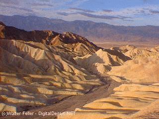
Warped Mountains
Time passed and the sea began to slowly recede to the west as land was pushed up. This uplift was due to the movment occurring far beneath the Earth's surface. Scientists have discovered that the Earth's crust is composed of a series of interconnected sections, or plates. The site of Death Valley lies adjacent to the boundary separating two of these plates. As the plates slowly moved in relation to each other, compressional forces gradually folded, warped and fractured the brittle crust. This widespread rock deformation and faulting occurred throughout most of the Mesozoic Era (250-70 million years ago). Active mountain building periods alternated with quiet times when forces of erosion worked to break down the mountains that had formed.GLOSSARY > erosion
Traveling Volcanos
The next phase in Death Valley's development was primarily influenced by volcanic activity that spanned much of the Tertiary Period (70-3 million years ago). As mountain building stretched the land surface, the crust was weakened. Hot, molten material beneath the surface welled up and erupted at these weak points. The seething volcanos first appeared to the northeast, in Nevada, and blanketed the Death Valley region with numerous layers of ash and cinders. The topography at that time consisted of gently rolling hills. Over time, the center of volcanic activity moved progressively westward, finally producing a chain of volcanos running from Furnace Creek to Shoshone. Secondary results of the ash and cinder eruptions include the vivid colors of the Artist's Palette and Death Valley's infamous borate mineral deposits.GLOSSARY > lava, volcanic
Basin and Range
Approximately three million years ago, the dynamics of crustal movement changed, and Death Valley proper began to form. At this time, compressional forces were replaced by extensional forces. This "pulling apart" of the Earth's crust allowed large blocks of land to slowly slide past one another along faults, forming alternating valleys and mountain ranges. Badwater Basin, the Death Valley salt pan and the Panamint mountain range comprise one block that is rotating eastward as a structural unit. The valley floor has been steadily slipping downward, subsiding along the fault that lies at the base of the Black Mountains. Down-dropping continues today. Evidence of this can be seen in the fresh scarps exposed near Badwater.GLOSSARY > escarpment
Erosion and Deposit
Concurrent with the down-dropping has been slow, but continous erosion. Water carries rocks, sand and gravel down from surrounding hills and deposits them on the valley floor. Beneath Badwater lies more than 9,000 feet of accumulated sediments and salts.GLOSSARY > deposition, erosion
Lost Lakes
In addition to structural changes, Death Valley has been subjected to major climatic changes throughout the last three million years. During North America's last major Ice Age, the valley was part of a system of large lakes. The lakes dissappeared approximately 10,000 years ago when the climate warmed. A shorter Ice Age, about 2,000 years ago, resulted in a smaller lake system. When this water evaporated, vast fields of salt deposits were left behind.GLOSSARY > pan, salt lake,
Yesterday's Volcano
Recent signs of volcanic activity exist in northern Death Valley at Ubehebe Crater. Caused by violent steam explosions, the craters formed only about 2,000 years ago when hot, molten material came in contact with groundwater. These large depressions indicate that not all is quiet beneath the surface of the Earth.GLOSSARY > volcanic
Shape of the Future
Death Valley's landscape has been changing since the begining of time. It is changing now, and will continue to change a long time after we have departed. The forces of erosion slowly carve away at the ancient rock formations, re-shaping the surface of the land. The basin continues to subside. It is interesting to imagine, but impossible to predict, the future of Death Valley.GLOSSARY > erosion
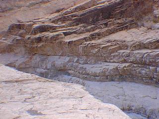
Strata
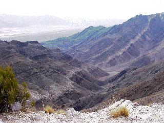
Warped mountains
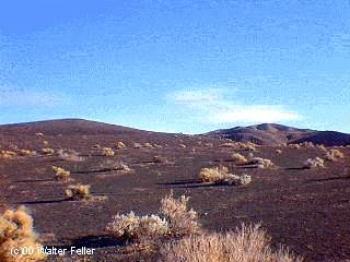
Volcanic lands
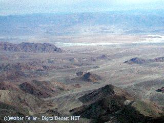
Looking east across Death Valley
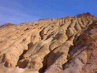
Eroded slope
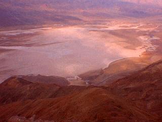
Death Valley Salt Pan
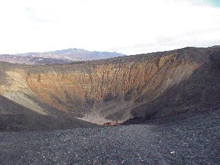
Ubehebe Crater
Impossible to predict the future of Death Valley