Death Valley's Lost 49ers
In January of 1848, gold was discovered at Sutter's Mill in California and people from all over the United States packed their
belongings and began to travel by wagon to what they hoped would be new and better life. Since most of these
pioneers began their exodus to California in 1849, they are generally referred to as 49ers. One of the supply
points along the trail was Salt Lake City, where pioneers prepared for the long journey across the
Great Basin desert before climbing over the
High Sierra Mountains
to the gold fields of California. It was important to leave
Salt Lake City and cross the desert before snow began to fall on the Sierra Mountains, making them impassible.
Only a couple of years before, a group of pioneers called the Donnor Party left late out of Salt Lake City
and was trapped by a storm, an event that became one of the greatest human disasters of that day and age.
The stories of the Donnor Party were still fresh on everyone's mind when a group of wagons arrived at
Salt Lake City in October of 1849. This was much too late to try to cross the mountains safely, and it looked
like these wagons were going to have to wait out the winter in Salt Lake City. It was then that they heard
about the
Old Spanish Trail,
a route that went around the south end of the Sierras and was safe to travel
in the winter. The only problems were that no pioneer wagon trains had ever tried to follow it and they could
only find one person in town who knew the route and would agree to lead them. As this wagon train left
Salt Lake City, some of these people would become part of a story of human suffering in a place they
named
Death Valley.
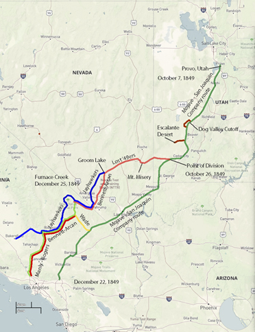
The first two weeks of travel on the
Old Spanish Trail
were easy, but the going was slower than most
of the travelers wanted. The leader of the group,
Captain Jefferson Hunt,
would only go as fast as the
slowest wagon in the group. Just as the people were about to voice their dissent, a young man rode into camp
and showed some of the people a map made by
John Fremont
on one of his exploratory trips through the area.
The map showed a short cut across the desert to a place called
Walker Pass. Everyone agreed that this would cut
off 500 miles from their journey so most of the 120 wagons decided to follow this map while the other wagons
continued along the Old Spanish Trail with Captain Hunt.
The point where these wagons left the Old Spanish Trail
is near the present day town of Enterprise, Utah where a monument (Jefferson Hunt Monument) has been constructed
to commemorate this historic event. Almost as soon as these people began their journey, they found themselves
confronted with the precipitous obstacle of Beaver Dam Wash, a gaping canyon on the present day Utah-Nevada state
line (Beaver Dam State Park, Nevada). Most of the people became discouraged and turned back to join
Jefferson Hunt,
but about 20 wagons decided to continue on. It was a tedious chore getting the wagons across
the canyon and took several days. In the mean time, the young man who had the map of the short cut got
impatient and, under the cloak of darkness, left the group. Despite the fact that the group didn't have a map,
they decided to continue on thinking that all they had to do was go west and they would eventually find the pass.
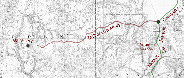
After crossing Beaver Dam Wash the group passed through the area of present day Panaca, Nevada and crossed
over "Bennett's Pass" to Del Mar Valley. Here they started having difficulty finding water but eventually found
their way to Crystal Springs in the Paranagat Valley. They continued over Hancock Summit into Tikaboo Valley
and then on to Groom Lake in central Nevada. They had now been slowly making their way across the desert for
almost a month since they had left the Old Spanish Trail . At Groom Lake they got into a dispute on which way
to go. One group wanted to follow a well traveled Indian trail to the south in hopes of finding a good water
source. The other group wanted to stay with the original plan of traveling west. The group eventually split
and went their separate ways but they both were to have two things in common. They were both saved from dying
of thirst by a snow storm and they both ended up meeting again in a place called
Ash Meadows
located east of Death Valley. From here they continued on through present day
Death Valley Junction
and along the same route followed by
Highway 190. On Christmas Eve of 1849, the group arrived at Travertine Springs,
located about a mile from
Furnace Creek.
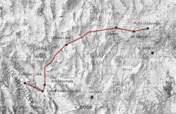
The lost pioneers had now been traveling across the desert for about two months since leaving the Old Spanish Trail.
Their oxen were weak from lack of forage and their wagons were battered and in poor shape. They too were weary
and discouraged but their worst problem was not the valley that lay before them. It was the towering mountains
that stood like an impenetrable wall as far as could be seen in both directions.
They decided to head toward what appeared to be a pass to the north near present day Stovepipe Wells, but after
discovering this was also impassible, decided they were going to have to leave their wagons and belongings
behind and walk to civilization. They slaughtered several oxen and used the wood of their wagons to cook the meat
and make jerky. The place where they did this is today referred to as "Burned Wagons Camp" and is located near the
sand dunes
of Death Valley. From here, they began climbing toward Towne Pass and then turned south over Emigrant Pass to
Wildrose Canyon. After crossing the mountains and dropping down into
Panamint Valley,
they turned south and climbed a small pass into Searles Lake Valley before making their way into
Indian Wells Valley near the present day city of
Ridgecrest.
It was here that they finally got their first look at the Sierra Mountains. They turned south, probably following a
trail and traveled close to the same route followed by Highway 14. Ironically, they walked right by Walker Pass
(Highway 178
to Isabella Lake), the place they had set out to look for almost three months earlier.
From Walker Pass,
they entered into what was to become the worst part of their journey, the
Mojave Desert Plateau.
This is a flat, featureless land with very few water sources to be found. The only things that saved them from
dying of thirst were a few puddles of water and ice from a recent storm. Eventually they found their way over a
pass near
Palmdale, California
and, following the Santa Clarita River drainage, were finally discovered and rescued by Spanish cowboys from
Rancho San Fernando, located near present day Newhall, California.
Source - NPS
Death Valley in '49
William Lewis Manly
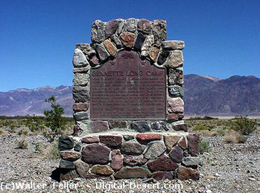
Monument at Bennett's Long Camp
Naming of Death Valley
...
Just as we were ready to leave and return to camp we took off our hats, and then overlooking the scene of so much trial, suffering and death spoke the thought uppermost saying:--"_Good bye Death Valley!"_ then faced away and made our steps toward camp. Even after this in speaking of this long and narrow valley over which we had crossed into its nearly central part, and on the edge of which the lone camp was made, for so many days, it was called Death Valley.
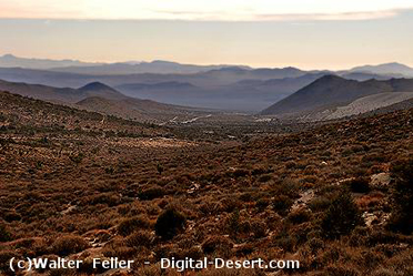
View toward Death Valley from the top of Walker Pass
"Ironically, they walked right by Walker Pass ..."
Manly and Rogers had to descend through the El Paso Mountains. Many believe they came through Last Chance Canyon to do so.
