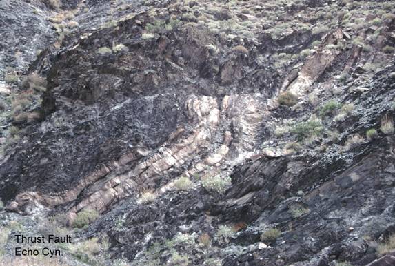
Echo Canyon/Thrust Fault
FC1b. Location/Access:(36o 29.723N; 116o 42.831W) The thrust fault is located 4.2 miles up the canyon from the biggest arch at stop FC1a. This is 8.7 miles from Highway 190. The fault can be seen on the southeast wall of the canyon.
Best Time: Late afternoon but avoid summer.
Geology: The thrust faults in the Funeral Mountains are mostly of Paleozoic Age and have been used to demonstrate the amount of tectonic motion laterally along the Death Valley Fault Zone by matching these thrusts with those in the Cottonwood Mountains northwest of Stovepipe Wells (Snow & Wernicke, 1989, and others following). For example, the Schwaub Peak thrust (in the upper Echo Canyon area) (Wright and Troxel, 1993) can be matched with the Marble Canyon thrust. Both thrusts have in excess of 3km of throw (Wernicke, et. Al., 1993). The total amount of displacement between these two localities is a matter of great debate among geologists working in the region because some of the motion is taken up by lateral movement along the Death Valley fault zone and probably much more by northwest-southeast Tertiary extension. The amount of displacement along the Furnace Creek-Death Valley fault zone has been calculated by many authors to be between about 15 and 65 km, however Cemen & Baucke (2005) measured offsets of the Clery thrust in Furnace Creek Wash just southeast of here to be about 35km. The actual mining camp of Schwaub, where you are now located is long gone, but by continuing a short distance further up the canyon, you arrive at the Inyo Mine which has several old buildings left from the early 1900s. The road ends just past the mine area but there is a terrible jeep road that leaves from the vicinity of the fault and heads towards Nevada.
=-=