Billie Mine/Ryan
FC4. Location/Access:(36o 20.043N; 116o 41.335W) This site is directly on the Dantes View Road 2.4 miles southeast of Highway 190. There is a long gravel shoulder on the east side of the road on which one can park.
Best Time: Afternoon, all year.
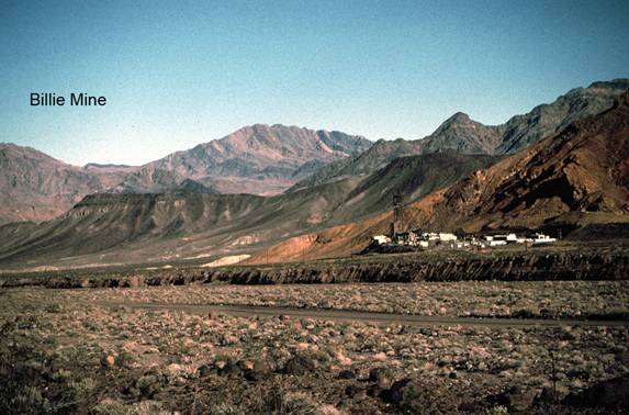
Geology: This site is located in the center of the main borate mining district of Death Valley. The actual national park boundary is directly along the road at this point so both the abandoned mining town of Ryan and the Billie mine visible in the near distance to the north are outside of the national park. Most of the borax minerals mined in Death Valley come from the Pliocene Furnace Creek formation. Here at the Billie mine, and previously at Ryan, these minerals are mined from shafts within this formation. West of the highway you can see a poor job of reclamation attempted to return the area to a natural condition after open pit mining was undertaken here in the 1970s. Specific minerals mined here include mostly proberite, ulexite and colemanite. One of the main reasons the Billie Mine was allowed to tunnel under the national park at this location is because of the relatively rare form of ulexite found in these deposits. The origin of the minerals is thought to be from hydrothermal fluids circulating through the Furnace Creek formation. As you look towards the abandoned mining camp of Ryan, the rocks to the left of the camp are the Artists Drive formation, to the right, the sediments of the Furnace Creek formation and on top, the basalt flows of the Funeral formation. Looking beyond the Billie Mine to the Funeral Mountains, one can see a sequence of upper Precambrian to lower Paleozoic strata tilting eastward.
=-=