Wildrose Graben
NP10. Location/Access:(36o 13.732N, 117o 15.138W) Wildrose graben is a shallow valley located near the western national park boundary 2.9 miles down canyon from the Wildrose townsite and 4.9 miles up the hill from the Wildrose-Panamint Valley Road junction. The Wildrose Road travels directly across it. Best Time: Late afternoon, all year.
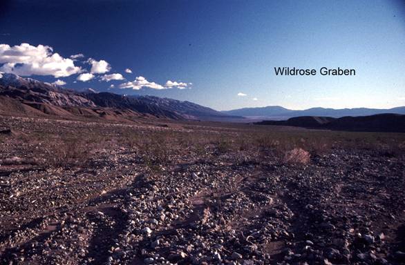
Geology: This very well known graben (down-dropped fault block) is about ¼ mile wide and about four miles long. The GPS coordinates are along the paved road about in the middle of the graben. There is a high angle normal fault that runs along the base of the bluffs to the west and another that runs along the base of the bluffs to the east. The bluffs to the west are composed of Pleistocene fan gravels and the lowest bluffs to the east are composed of the same but the main trace of the Panamint Mountains frontal fault lies just beyond to the east and uplifts the Miocene (?) continental deposits and the whole mass of the Panamint Mountains which here are composed mostly of the Proterozoic Pahrump Group. From these relationships, the graben is most likely of late Pleistocene age, probably a few hundred thousand years old. Looking down the graben in the distance, one can see a flat surface extending westward from the Panamints and lying distinctly above the valley floor. This is a Pleistocene age delta formed when sediments were being deposited into the Pleistocene lake that filled the Panamint Valley during the ice ages. This lake was deeper but not as long as Lake Manly that filled Death Valley at the same time.
=-=