Digital-Desert : Mojave Desert >>> Route 66 <<<
From the Heartland to the Coast
Photography by
Walter Feller
features - ecology: wildlife - plants - geography: places - region map - map/sat - roads & trails: route 66 - video - aerial - 360 photos - old west - communities - lodging
ghost towns - gold mines - parks & ...: joshua tree - death valley - mojave preserve - wilderness - native culture - history - geology: natural features - glossary - comments
Northern Panamint Region

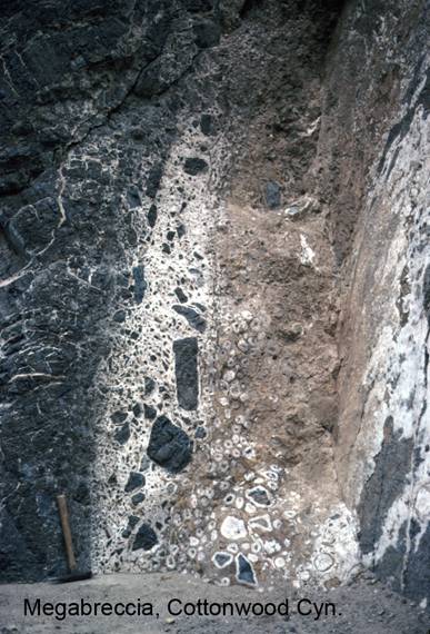
Cottonwood Canyon/Megabreccia

NP2c. Location/Access:
(36o 34.214’N; 117o 19.405’W) Site NP4c is located 1.4 miles beyond the cave and 16.0 miles from Stovepipe Wells. The megabreccia is at eye level on the right canyon wall.

Best Time: Anytime in the cool half of the year.

Geology: This site is very similar to Site GF2i in Titus Canyon except that this site is smaller and the breccia fragments are smaller and rounder. One would assume that the origin is similar: The limestone was being pulled apart as groundwater precipitated travertine around the fragments as they moved apart. Again, the movement is assumed to be of tectonic origin. Notice here, in comparison to Titus Canyon, that there is a very well-defined precipitate rim around some of the particles. Groundwater was and is obviously very active here in Cottonwood Canyon as all of the sties in Cottonwood Canyon have groundwater components to their explanation.


features - ecology: wildlife - plants - geography: places - region map - map/sat - roads & trails: route 66 - video - aerial - 360 photos - old west - communities - lodging
ghost towns - gold mines - parks & ...: joshua tree - death valley - mojave preserve - wilderness - native culture - history - geology: natural features - glossary - comments
Country Life Realty
Mountain Homes and Real Estate for Sale

~ Wickless Candles by Scentsy ~
The Most Wonderful Time of the Year ...
... Is here
MH Sleds
Saucer sleds for the snow
Life time guarantee!!!

Abraxas Engineering
privacy
Copyright ©Walter Feller. All rights reserved.