Joshua Tree National Park Geology
Geography
Go my sons. buy stout shoes, climb the mountains, search the valleys, the deserts, the sea shores, and the deep recesses of the earth...for in this way and in no other will you arrive at a knowledge of the nature and properties of thingsP. Severinus (Circa 1778)
Location and Physiography
Joshua Tree National Monument is on the eastern end of the broad mountainous belt called the Transverse Ranges (Figure 1). The Tranverse Ranges stretch from Point Arguello, 50 miles west of Santa Barbara, eastward for nearly 300 miles to the Eagle Mountains in the Mojave Desert.The Monument region is made up of several distinct mountain ranges, the Little San Bernardino Mountains in the southwestern part, the Cottonwood, Hexie, and Pinto Mountains in the center, and the Eagle and Coxcomb Mountains in the eastern part. Both the southern and northern margins of the Monument are marked by steep escarpments that rise abruptly from the lower desert areas. Much of the Monument lies at elevations above 4,000 feet.
Valleys lying between these mountain ranges are of two types, those that have been formed by downdropping along faults (grabens or structural basins), and those that have been carved by erosion. Pleasant Valley, between the Little San Bernardino and Hexie Mountains, is an example of the structural type; Queen Valley, in the central part of the Monument, is an example of the eroded type.

Figure 1. Location of Joshua Tree National Park.
Climate
The climate of the high desert of the Joshua Tree region is that of a mid-latitude desert with relatively moderate temperatures. For example, the average temperature at Twentynine Palms, elevation 2000 feet, is only 67.3�F (19.6�C), and at Hidden Valley Campground the average temperature is about 62�F (17�C) There are two factors causing eastern California to be a desert: 1) the "rain shadow" effect produced by the high mountains on the west, and 2) the existence during summer months of a semi-permanent high-pressure air mass, the Hawaiian High, which builds up over the northeastern Pacific Ocean and blocks the passage of frontal storm systems over California. Occasionally during the summer and fall the Hawaiian High weakens and moist air slips into the region across Arizona from the Gulf of Mexico bringing thunderstorms. For this reason August has the highest rainfall (Table 1) which, curiously enough, is usually the driest month for the more humid portions of the state.Table 1. Twentynine Palms Oasis weather record. The averages were compiled from the 44-year record (1936 through 1979). U.S. National Park Service, 1980.
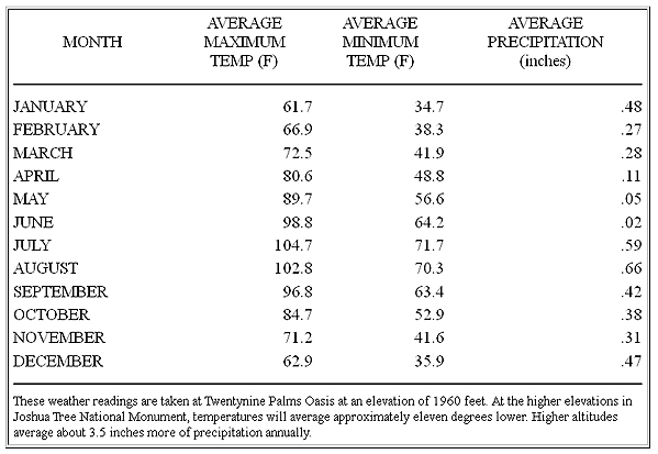
In the winter months the Hawaiian High usually dissipates and southern California receives an average of four or five frontal storms that originate in the northern Pacific. At this time the second rainy season in the desert occurs in December and January (see Table 1). The average rainfall at Twentynine Palms is only a little over four inches but at higher elevation the average rainfall increases. The Joshua trees serve as a rain gauge in those areas of the desert where no records are kept because they require 10 inches or more of annual rainfall in order to survive.
