| Digital-Desert : Mojave Desert |
>>> Route 66 <<< From the Heartland to the Coast |
Photography by Walter Feller |
| features - ecology: wildlife - plants - geography: places - region map - map/sat - roads & trails: route 66 - video - aerial - 360 photos - old west - communities - lodging |
| ghost towns - gold mines - parks & ...: joshua tree - death valley - mojave preserve - wilderness - native culture - history - geology: natural features - glossary - comments |
Golden Canyon Geology Tour
An Abrasive SituationIn February 1976, a four-day storm dropped 2.3 inches of rain at Furnace Creek. On the last day of the storm, a violent downpour caused a surge of water, mud, and rock to flow through these narrows.Such sediment-laden floods work like sandpaper, cutting away and undermining the rocky canyon walls. In narrows such as these, flood waters are constricted and the speed increases. If you look closely at the walls of the canyon. you will see a coating of mud that indicates the height of the water that has moved through these narrows. Flash floods like these have been shaping the canyons of Death Valley for millions of years. < Previous - Next >
|
click the photo to continue ![]() 
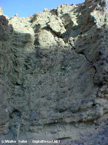
Coating of mud on lower canyon wall shows storm water level |
| features - ecology: wildlife - plants - geography: places - region map - map/sat - roads & trails: route 66 - video - aerial - 360 photos - old west - communities - lodging |
| ghost towns - gold mines - parks & ...: joshua tree - death valley - mojave preserve - wilderness - native culture - history - geology: natural features - glossary - comments |
|
Country Life Realty Mountain Homes and Real Estate for Sale |
~ Wickless Candles by Scentsy ~ The Most Wonderful Time of the Year ... ... Is here |
MH Sleds Saucer sleds for the snow Life time guarantee!!! |
|
Abraxas Engineering privacy |
Copyright ©Walter Feller. All rights reserved. |