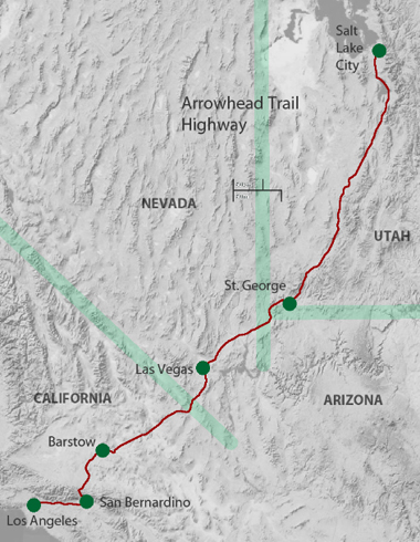
Arrowhead Trail - U.S. 91
The Arrowhead Trail — Utah's Wonderful Route
Motor West - Sept. 1, 1917The Arrowhead Trail, that leads from Salt Lake City- south through the fertile valleys along the Wasatch range to Utah"s "Dixieland" on the Virgin River, has a charm all its own. From a scenic point of view, it can scarcely equal the charms of some of the other famous roads of the West, yet it leads to the wonderful "Little Zion" canyon, a 3000-foot gorge through colored walls of sandstone unlike anything to be found elsewhere in the United States.
There is historic charm, too. about the Arrowhead Trail. The first white man to blaze this trail afterwards became a prominent citizen of Los Angeles. In 1830 William Wolfskill led a party of hunters and trappers from Santa Fe, north through Gunnison Valley, across the San Juan and the Colorado rivers, west to the Wasatch range and thence southwest to the Rio Virgin and to Los Angeles across the Mojave desert. It was such an easy route that its fame spread, and it was traveled later by Kit Carson and General Fremont.
When the Mormons settled Salt Lake City, in 1847, it did not take long for the Arrowhead Trail to come into its own. Settlements of Mormons pushed south from Salt Lake at the command of Brigham Young, and founded the chain of prosperous Utah farming communities that the Arrowhead Trail leads through today. Then through Capt. Jefferson Hunt of the famous Mormon battalion word came back to Salt Lake City of the paradise for the settler that was to be found in Southern California. Young was eager to add this country to his dominion and called for volunteers to settle at San Bernardino. To his surprise and dismay, five hundred volunteers answered his call instead of the fifty or so that he expected, and this train of emigrants followed the Arrowhead Trail to San Bernardino and founded what is now the city of that name.
Between the flourishing Mormon community at San Bernardino and the parent city at Salt Lake there naturally sprung up much travel over the Arrowhead trail. The fact that the winter snows blocked all other routes out of Salt Lake City for much of the year contributed still further to the importance of the Arrowhead Trail of sixty years ago. Here is what Harris Newmark. pioneer of Los Angeles, has to say concerning the Arrowhead Trail of that day :
"Each winter for 15 or 20 years, until railroad communication was established, a lively and growing trade was carried on between Los Angeles and Utah. This was because the Mormons had no open road toward the outside world except in the direction of Southern California, for snow covered the Rockies and the Sierra Nevadas and closed every other highway and trail. A number of Mormon wagon trains therefore went back and forth even, winter over the 700 miles and more of fairly level open roadway between Los Angeles and Salt Lake, taking back not only goods bought here, but much that was shipped from San Francisco to Salt Lake via San Pedro. I remember that in February, 1859, these Mormon wagons arrived almost daily."
 St. Thomas, Nevada
How primitive life was in Los Angeles in that day may be judged from the fact that Mr. Newmark elsewhere comments that Phineas Banning journeyed to Salt Lake City and brought back over the Arrowhead Trail the first wagons with spokes ever seen in Los Angeles. The solid-wheeled carreta had prevailed up to that time.
When the railroad came, of course the through travel on the Arrowhead Trail stopped, and it was only two years ago that it re-commenced, when Los Angeles good road men drew attention to the fact that this was the logical automobile route to Salt Lake Citv. So enthusiastically was the idea received and so earnest has been the labor of the communities along the road to improve it, that as many as 200 parties of motorists are now traveling the Arrowhead Trail each month. Through its length in Utah the Arrowhead Trail passes through village after village all of the same general type. The traveler will carry with him memories of pleasant and peaceful towns, with comfortable homes of pink brick, of streets shaded by cottonwoods, with irrigating ditches running on either side, and ranges of cloud-piercing mountains guarding the land.
Arrowhead (Trails) Highway
Arrowhead [Trails] Highway The Arrowhead Highway-was the first “scenic highway” through southern Utah. The concept of such a route was proposed in 1914 by businessmen in Las Vegas, to encourage automobile tourism between Los Angeles, CA and Salt Lake City, UT, through southern Nevada.Their proposed route followed the route of a late 19th century wagon road, the “Old Mormon Road” and the earlier “Old Spanish Trail”. Touring clubs and local communities in southern California, Nevada, and Utah published maps and promoted tourist travel on “the Arrowhead Trail”. As few segments of the route were constructed roads, mechanical breakdowns, flat tires, and overheated engines in remote areas challenged even the most adventurous travelers.
In 1918, the first stretches of road in southern Utah were improved by Washington County prison work crews and laborers from St. George and Santa Clara, working with horse teams and “Fresno scrapers”. The route of the Arrowhead Highway through Beaver Dam Wash NCA closely followed the alignment of the later paved U.S. Highway 91. Artifacts and structures associated with early service stations that supplied water, gasoline, tire repairs and overnight tent camping areas to travelers on the Arrowhead Highway have been documented in the NCA.
BLM - Utah
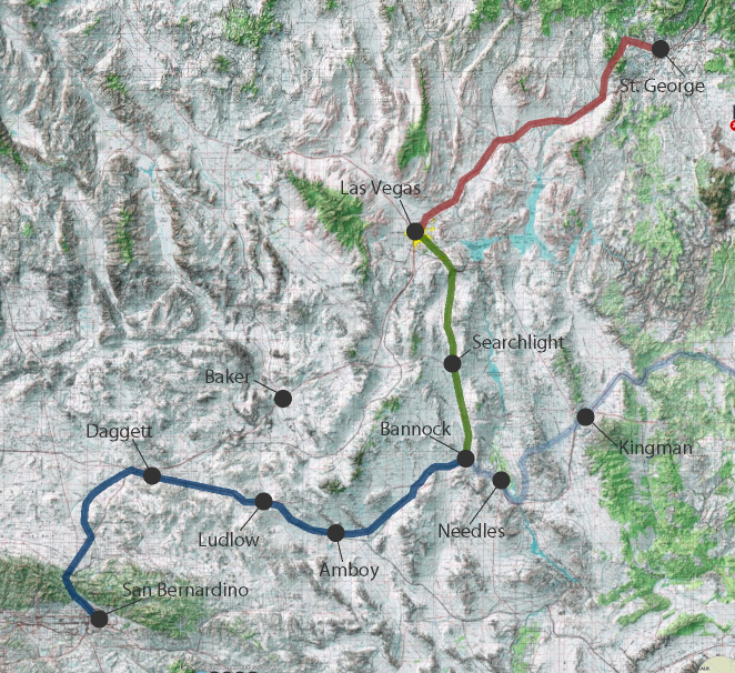
The initial Arrowhead route extended from Bannock near Needles north to Las Vegas while the Baker Cutoff was being designed and built to work within the Old Spanish Trail corridor. The deep, soft sands of the Devil's Playground and Afton Canyon prevented the use of the Mojave Road as a road suitable for motor vehicles.
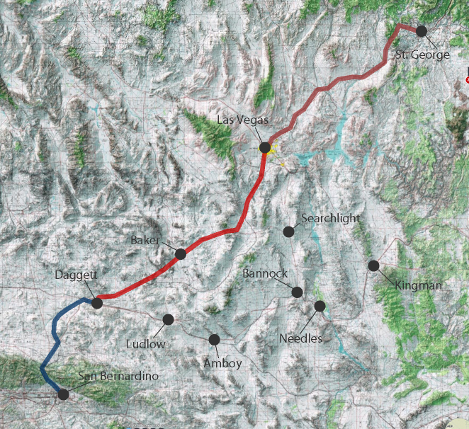
After the road was designed and built to bypass both the sandy river canyon and the unfortunately located Silver Lake community the Arrowhead Trail was redesignated to follow the new alignment.
Carreta - note the solid wheels.
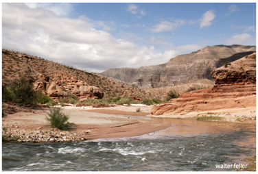
Virgin River
