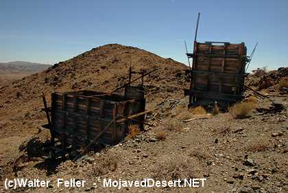
Silver Bell Mine
Clearly visible in the eastern Hexie Mountains about .75 mile from the Pinto Basin Road west of the cholla cactus garden
is the Silver Bell Mine. Two
ore
bins, a dirt-covered shelter, and an abandoned mine road are all that remain.
The mine operated between 1934 and 1962 producing minimal amounts of gold, silver, lead and copper.
The ore bins held and fed rock to a stamp battery that crushed
the ore into a sandy-watery pulp and pushed in on to an amalgamation
table where presious metals were extracted. Though the mine operated
some 40 years, ownership and details about the mine's riches are
sketchy. Nevertheless, it was a versatile mine: gold in the 1930s, lead in the 1940s,
and copper in the 1950s.
Prospectors began staking claims in this desert region around
1865. Gold fever gave rise rise to mine names like Fore Aces,
Big Bozo Claim, Lucky Turkey #2, and Hard Digging. Mining
reached its peak in the area by 1917 and tapered off by the 1960s.
Ore was hoisted from the Silver Bell Mine by the skip and dumped
onto the grizzly, which sorted ore into the tipple. A 1958 assay report showed
the Silver Bell Mine as having low gold and silver values but high copper
values--worth about $90 a ton.
Note - Mine shafts and adits are unstable and may be filled with
harmful gases. Use great caution around old mine workings and
leave them undisturbed. Collecting rocks and artifacts
is prohibited.
Geology - The workings follow a fault zone containing gold-bearing quartz veins within gneiss.
Primarily - Creosote bush scrub habitat.
Faults in Joshua Tree