Coso Volcanic Field
The Coso volcanic field, located east of the Sierra Nevada Range at the western edge of the Basin and Range province consists of Pliocene to Quaternary rhyolitic lava domes and basaltic cinder cones covering a 400 sq km area. Much of the volcanic field lies within the China Lake Naval Weapons Center. Active fumaroles and thermal springs are present in an area that is a producing geothermal field. The youngest eruptions were chemically bimodal, forming basaltic lava flows along with 38 rhyolitic lava flows and domes, most with youthful, constructional forms. The latest dated eruption formed the Volcano Peak basaltic cinder cone and lava flow and was Potassium-Argon dated at 39,000 +/- 33,000 years ago. Although most activity ended during the late Pleistocene, the youngest lava dome may be of Holocene age based on geomorphological evidence (Monastero 1998, pers. comm.).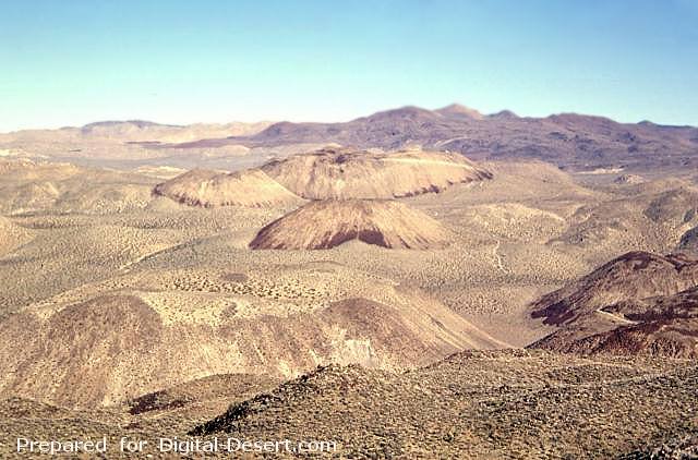
The Coso volcanic field at the western edge of the Basin and Range province consists of largely Pliocene to late-Pleistocene rhyolitic lava domes and basaltic cinder cones covering a 400 sq km area. This view looks south across the range from Cactus Peak with some of the 38 light-colored rhyolitic lava domes of the Coso volcanic field in the foreground and dark-colored basaltic cinder cones and associated lava flows in the background. Active fumaroles and thermal springs are present in an area that is a producing geothermal field.
Photo by Paul Kimberly, 1997 (Smithsonian Institution).
Country: United States
Subregion Name: California (USA)
Volcano Number: 1203-18-
Volcano Type: Lava domes
Volcano Status: Holocene?
Last Known Eruption: Unknown
Summit Elevation: 2400 m 7,874 feet
Latitude: 36.03°N * 36°2'0"N
Longitude: 117.82°W 117°49'0"W