Inyo Craters
The Inyo Craters are a 12-km-long chain of silicic lava domes, lava flows, and explosion craters along the eastern margin of Sierra Nevada south of Mono Craters near the town of Mammoth. Inyo Craters overtop the NW rim of the Pleistocene Long Valley caldera and extend onto the caldera floor, but are chemically and magmatically part of a different volcanic system. Postglacial explosion pits of Mammoth Mountain to the south are an extension of Inyo Craters (Bailey 1980). The latest eruptions at Inyo Craters took place about 600 years ago, when explosive eruptions accompanied formation of the South Deadman, Obsidian Flow, and Glass Creek rhyolitic lava domes and lava flows. The Inyo Crater Lakes are small phreatic craters that formed during this eruption on the south flank of the Pleistocene Deer Mountain rhyolite dome of the Long Valley caldera.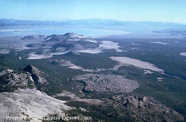
The Mono Craters volcanic field south of Mono Lake at the upper left, is a 17-km-long arcuate chain of rhyolitic lava domes and thick, viscous lava flows. Mono Craters has been frequently active throughout the Holocene, along with the Inyo Craters chain to the south. The Inyo Craters chain, which includes the Wilson Butte, Obsidian and Glass Creek domes, which are oriented diagonally along a N-S line from the left center to lower right of the photo. The latest eruptions of Mono Craters and Inyo Craters occurred nearly simultaneously around 600 years ago.
Photo by Roy Bailey, 1980 (U.S. Geological Survey).
Country: United States
Subregion Name: California (USA)
Volcano Number: 1203-13-
Volcano Type: Lava domes
Volcano Status: Radiocarbon
Last Known Eruption: 1380 ± 50 years
Summit Elevation: 2629 m 8,625 feet
Latitude: 37.692°N 37°41'30"N
Longitude: 119.02°W 119°1'0"W