Mammoth Mountain
Mammoth Mountain, a trachydacitic lava-dome complex, lies on the SW topographic rim of Long Valley caldera. The 3369-m-high volcano lies west of the structural rim of the caldera and is considered to represent a magmatic system distinct from Long Valley caldera and the Inyo Craters (Hildreth, 2004). The latest magmatic eruptions at Mammoth Mountain took place about 57,000 years ago. Mammoth Mountain is surrounded by at least 35 mafic vents that are part of the same magmatic system and include Red Cones, two closely spaced basaltic cinder cones located SW of Mammoth Mountain and SE of Devils Postpile National Monument. The cones, whose name derives from colorful mantling scoria deposits, are unglaciated and were radiocarbon dated at about 8900 years ago. Phreatic eruptions, distinct from those at South Inyo Craters, took place about 700 years ago from vents on the north side of Mammoth Mountain. Recent unrest, including seismicity, gas emission, and tree kill, is thought to be related to dike intrusion beneath Mammoth Mountain in 1989.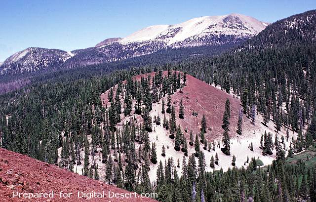
Mammoth Mountain, a Pleistocene trachydacitic lava-dome complex constructed on the SW topographic rim of the Long Valley caldera between about 200,000 and 50,000 years ago, forms the broad peak on the horizon. The Red Cones (center and lower left) are part of series of about three dozen mafic cones surrounding Mammoth Mountain. The oxidized reddish scoria of the cone, which was formed during the early Holocene, is mantled at its base by light-colored pumice erupted from the Inyo Craters about 650 years ago.
Photo by Lee Siebert, 1998 (Smithsonian Institution)
Country: United States
Subregion Name: California (USA)
Volcano Number: 1203-15-
Volcano Type: Lava domes
Volcano Status: Radiocarbon
Last Known Eruption: 1260 ± 40 years
Summit Elevation: 3369 m 11,053 feet
Latitude: 37.631°N 37°37'50"N
Longitude: 119.032°W 119°1'54"W