Mono Craters
The Mono Craters, lying on the eastern side of the Sierra Nevada between Mono Lake and Long Valley caldera, form an arcuate, 17-km-long group of 30 or more dominantly rhyolitic lava domes, lava flows, and tephra rings. The partially overlapping dike-fed domes were erupted near the margin of a pull-apart basin on the east side of the Sierra Nevada. Explosive eruptions began more than 50,000 years ago from now-buried vents, but almost all of the exposed domes and flows are of Holocene age. Activity has propagated both north and south from the center of the chain during the late Holocene. The latest eruptions occurred about 600 years ago, nearly contemporaneously with the eruptions from Inyo Craters to the south, producing a series of tephra rings and obsidian lava domes and flows at the northern end of the chain accompanied by eruption of locally extensive tephra layers.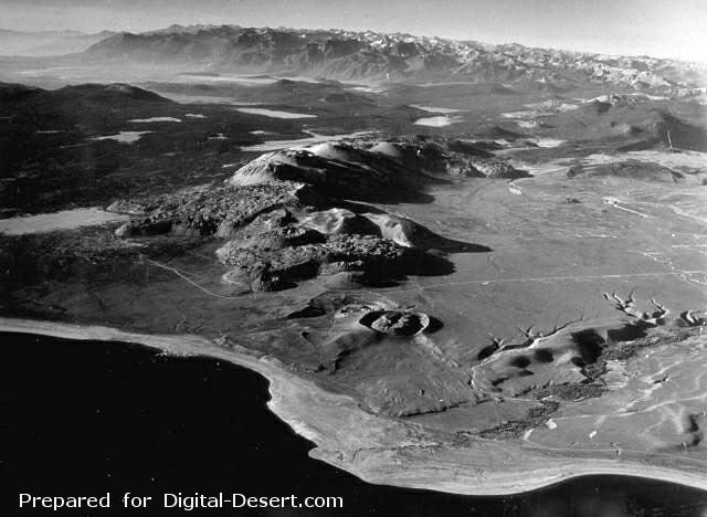
The Mono Craters volcanic field, between Mono Lake in the foreground and Long Valley caldera at the upper left, is a 17-km-long chain of rhyolitic lava domes and thick, viscous lava flows. Mono Craters have been frequently active during the Holocene. Panum crater (the vent nearest to Mono Lake), is partially filled by a lava dome and was the site of the latest eruption from Mono Craters, about 600 years ago.
Photo by R. Von Huene, 1971 (U.S. Geological Survey).
Country: United States
Subregion Name: California (USA)
Volcano Number: 1203-12-
Volcano Type: Lava domes
Volcano Status: Radiocarbon
Last Known Eruption: 1350 ± 20 years
Summit Elevation: 2796 m 9,173 feet
Latitude: 37.88°N 37°53'0"N
Longitude: 119.00°W 119°0'0"W