Desert Landforms & Surface Processes
ABSTRACT: Landscape features in the Mojave National Preserve are a product of ongoing processes involving tectonic forces, weathering, and erosion. Long-term climatic cycles (wet and dry periods) have left a decipherable record preserved as landform features and sedimentary deposits. This website provides and introduction to climate-driven desert processes influencing landscape features including stream channels, alluvial fans, playas (dry lakebeds), dunes, and mountain landscapes. Bedrock characteristics, and the geometry of past and ongoing faulting, fracturing, volcanism, and landscape uplift and subsidence influence the character of processes happening at the surface.Introduction
Several hundred thousand people travel along Interstate 15 between Los Angeles and Las Vegas every week, but typically less ...Physiography
The Mojave Desert comprises the southwestern quadrant of the Basin and Range physiographic province, a vast region dominated by ...Weather Data
Historic weather data for the Eastern Mojave Desert is relatively scarce because there are no significant ...Geologic History
The oldest rocks exposed in the eastern Mojave Desert are between 1.7 and 2.5 billion years old (early Proterozoic age). They consist ...Changing Climates
The impact of both long-term and short-term climatic changes can be seen on the landscape. ...Weathering and Erosion
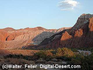
Mountains form because, over long periods of time, uplift proceeds faster than erosion can keep pace. Through time, erosion progressively carves ...Carbonate Rocks
In the Mojave, carbonate sedimentary rocks of Proterozoic and Paleozoic age crop out throughout the ...Granitic Rocks
Weathering and erosion in arid regions underlain by granitic bedrock produce unique characteristic landforms. ...Volcanic Rocks
Evidence of past volcanism can be seen throughout the Mojave Desert region. Two notable areas that display volcanic rocks and ...Faults
Faults range in scale and complexity from small, simple offset measurable in inches or feet to massive thrust faults, normal faults, and ...Pediments
The term, mountain front, is an imaginary borderline between a mountainous area and a low, ...Stream Channels
Progressive landscape development in any particular area is a function of many factors including climate, vegetation, slope ...Stream Terraces
Stream terraces form when streams carve downward into their floodplains, leaving discontinuous remnants ...The Mojave River
At its peak during this last ice age, the Mojave River drainage basin extended from the San Bernardino Mountains in the west; it flowed east and north ultimately merging with the Amargosa River before draining into ...Playas
Although playas may appear as featureless plains, they are rich in features and characteristics thatSand Dunes
The moving sand will stall and accumulate as dunes where the wind rises over a barrier (such as a mountain range). However, for dunes to persist, ...Human Impacts
Evidence of human history in the Mojave region extends back to when perennial lakes existed in the region at the close of the Pleistocene, ...References
... Next >Introduction
From:
Desert Landforms and Surface Processes in the Mojave National Preserve and Vicinity
By Philip Stoffer
U.S. GEOLOGICAL SURVEY
U.S. DEPARTMENT OF THE INTERIOR
Western Earth Surface Processes Team
2004
USGS Western Region Geology and Geophysics Science Center
The updated (2009) URL is http://pubs.usgs.gov/of/2004/1007/
Use of any trade, firm or product name is for descriptive purposes only and does not constitute endorsement by the U.S. Government.
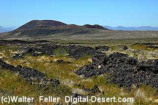
Cinder Cones
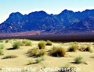
Providence Mountains
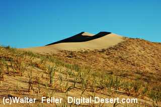
Kelso Dunes
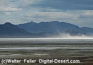
Soda Lake (playa)
Afton Canyon - Mojave River
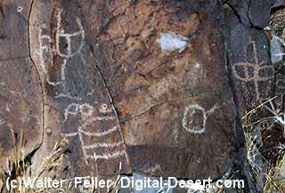
Evidence of prehistoric man
