Digital-Desert : Mojave Desert Visit us on Facebook -- Desert Gazette -- Desert Link
Intro:: Nature:: Map:: Points of Interest:: Roads & Trails:: People & History:: Ghosts & Gold:: Communities:: BLOG:: Weather:: :?:: glossary
Mojave Road

Rudolph D'Heureuse


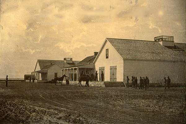
Drum Barracks - 1863

The Photographic Views of the Mojave Route, El Dorado Canyon and Fort Mojave collection contains photographic prints taken by Rudolph D'Heureuse in 1863. Pictured in the collection is the Mojave Desert region from the San Bernardino Valley and Cajon Pass eastward to the Colorado River and Fort Mojave of Arizona. The reason D'Heureuse photographed this section of the "Mojave Road" and the adjacent region is unclear. It is most likely that he was surveying the area in association with either the Macedonia Mining District or the California State Geological Survey. D'Heureuse's work is considered to be the earliest extant body of survey photographs of this region.

UC Berkeley, Bancroft Library


Mojave Road in 1863

San Bernardino, Ca. to Fort Mojave, Az.

Mojave Road

Mojave River Trail

Cajon Pass
Intro:: Nature:: Map:: Points of Interest:: Roads & Trails:: People & History:: Ghosts & Gold:: Communities:: BLOG:: Weather:: :?:: glossary
Country Life Realty
Wrightwood, Ca.
Mountain Hardware
Wrightwood, Ca.
Canyon Cartography
DesertLink
Links to Desert Museums

Grizzly Cafe
Family Dining


Custom Search

AbeBooks
Abraxas Engineering
privacy
These items are historical in scope and are intended for educational purposes only; they are not meant as an aid for travel planning.
Copyright ©Walter Feller. 1995-2023 - All rights reserved.
6355