Large-scale Sand Accumulation Features
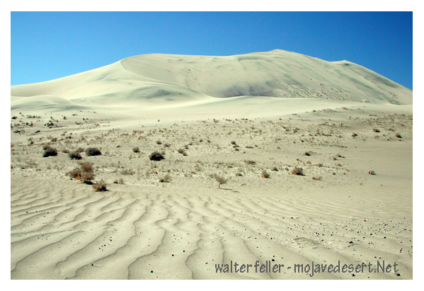
Eureka Dunes - Death Valley National Park
According to Bagnold (1941), certain conditions must be met for flat sandy areas to build up into true dunes. The primary prerequisites are relatively strong winds and a fine-grained surface. Coarse sand grains and pebbles tend to stabilize a surface of sand by preventing light or moderate winds from moving the finer grain sand mixed in the coarser material. Bagnold has observed that large sand sheets (without dunes) are generally covered with coarse sand or small pebbles and are generally devoid of ripples. Only strong winds can remove the finer grains from amidst the coarse grains and carry them downwind where they can form dunes by self-accumulation. The rougher the surface of a source of sand (the more coarse material mixed with the finer sand) the stronger the winds needed for dune formation. Also, sandy areas with periodic wet-season rainfall may also be prevented from developing dunes by a light, intermittent vegetation.
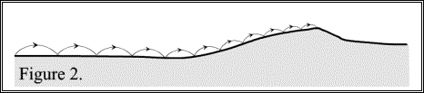
Assuming a steady input of sand from an upwind source, any patch of sand that meets the above conditions and is four to six meters long can develop into a true dune. (A true dune generally refers to a self-accumulating mound of sand with a distinct slip-face, as opposed to an obstacle formed pile of sand, such as a sand shadow, which will not be discussed in this paper.) Saltation drag is a primary factor contributing to dune formation. Wind speeds are highest and saltation drag is least at the windward edge of a sandy patch. The further downwind on the sand, the greater the drag and the slower the winds, resulting in differential sand movement across the sandy surface. As the movement of grains slows toward the leeward side of the sandy area, accumulation of sand increases and sand begins to mound up on the leeward end (Bagnold, 1941) (Figure 2).
As the sand mound grows, the point of maximum sand deposition on the leeward face moves closer to the summit, causing a steepening of the leeward face relative to the windward face. The steepening and growing dune now forces wind out over the top of the dune rather than down the leeward face. The saltating sand drops out at the crest and further steepens the leeward face until it reaches its angle of repose (about 32 to 34 degrees for dry sand), at which time gravity may pull sand from the crest down the leeward slope in the form of either isolated slow-flowing avalanches or the shearing and slumping of whole blocks of sand. This sand movement by slippage rather than by saltation or creep has earned the leeward face of an advancing dune the name of "slip-face" (Bagnold, 1941).
The slip-face is an effective sand trap. Bagnold's field observations on barchans showed that even in strong winds a near-perfect wind shadow exists along the slip-face. Any sand driven up the windward slope drops out as it hits the stagnant air above the slip face, resulting in renewed steepening of the slip-face near the crest of the dune until the angle of repose is once again reached. Thus, entire dunes slowly move downwind due to avalanching and slumping along the slip-face. The rate of dune advance is directly related to the rate of sand movement over the dune crest and inversely related to the height of the slip-face, i.e. as dunes grow in height their forward movement slows (Bagnold, 1941).
Sand dunes of many different types have developed, resulting in various classification schemes and descriptive terminology as well as a considerable amount of confusion. Regardless of what terminology and classification scheme is used, most students of dune formation would agree with Bagnold's assertion that dune accumulation "is intimately connected with the relative strength, duration and direction of alternating periods of weak and strong winds" (1941, p. 184).
Bagnold felt that strong winds tended to build up dunes in terms of height, while gentler winds generally extend the length of the dunes at the expense of height. Cooke and Warren (1973, p. 271) explain this phenomenon as follows: "a wind capable of moving sand over a sandy surface could not move it over a pebbly surface, so that a sand patch would be eroded and extended downwind by such a wind. A stronger wind on the other hand might move more sand over pebbles, because of the better rebound from the harder surface...and the sand patch grows."
Because it is generally agreed that the primary determinant of dune forms in any given area is the nature of the wind regime of that area, most dune classification schemes are based primarily on the direction(s) and intensity of the winds carrying the sand, although other factors, such as abundance of sand, presence or absence of vegetation, topography, the nature of surface material and the dominant grain size of the sand are also contributing factors and must be taken into consideration (Borsy, 1976; Fryberger and Ahlbrandt, 1979).
Borrowing heavily from other studies, McKee (1979) has developed a modern descriptive typology of dunes, although he also includes a generic explanation of the different types and subtypes he describes. McKee presents two related classification systems, one dealing with the basic shape and structure of individual dunes (based primarily on modifications of Bagnold's classification) and a second dealing with the complexity of pattern displayed by groups of dunes (based on field observations and remote sensing studies).
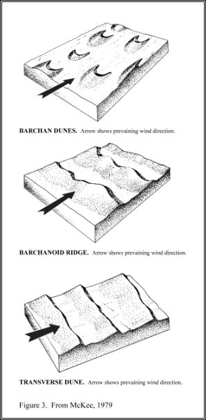
McKee classifies individual dunes in terms of the number and position of slip-faces, under the assumption that the number of slip-faces corresponds to the number of dominant wind directions in the local wind regime. Most dunes that have a single slip-face are classified in the "barchanoid" type, which consists of three intergrading subtypes: the barchan, the barchanoid ridge, and the transverse dune (Figure 3). All are considered to have axes perpendicular to a persistent, unidirectional wind regime.
McKee feels that the primary difference among the three barchanoid subtypes is the amount of sand available for dune formation.
Barchans, despite their familiar crescentic shape, comprise only a small percentage of the world's dune areas and tend to develop where limited amounts of sand are available. For example, individual barchans have formed in the vicinity of the Salton Sea, with little or no sand found in areas adjacent to the dunes (Shelton, Papson, and Womer, 1978).
Maximum dimensions for individual barchans are approximately thirty meters in height and four hundred meters in width and length (Bagnold, 1941). Their relatively small size allows for rapid movement; individual barchans in Peru advance as much as forty-seven meters annually (Cooke and Warren, 1973).
As more sand becomes available, barchans merge into wave-like barchanoid ridges; and, if sand continues to accumulate, the barchanoid ridges grade into transverse dunes. These larger barchanoid subtypes can reach heights of over two hundred meters and extend for kilometers (Bagnold, 1941). This gradation of forms is similar to that of sand forms created by water currents. In laboratory experiments, Tyler (1979) observed "dunes" on sandy stream beds develop from barchan to barchanoid ridge to transverse forms.
An additional type of dune with a single slip-face is the parabolic dune, with a crescentic form opposite that of the barchan (i.e. with horns pointed upwind). Parabolic dunes develop when vegetation begins to colonize the moister, less-mobile flanks of self-accumulating dunes. Vegetation has a stabilizing effect on the dune, retarding or completely stopping movement along the edges of the dune arms. The leading edge of the dune may continue to push forward and move ahead of the arms, creating the typical reverse-crescent shape. Eventually, the nose of the dune may be stabilized by vegetation as well, or it may continue to progress, breaking free of the arms and leaving two vegetated linear ridges in its wake (Cooke and Warren, 1973; McKee, 1979).
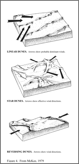
McKee recognizes two dune forms that display two slip-faces each, presumably a result of bimodal wind regimes. The linear (or seif) dune is the most common of all inland dunes and the most controversial in origin (Figure 4). These long, narrow dunes have sharp, steep crests due to the presence of a slip-face on both sides. Bagnold recorded linear dunes in Iran that were over two hundred meters high, twelve hundred meters wide and one hundred kilometers long.
While it is generally agreed that the dual slip-face structure of the linear dune does represent the work of winds from two different directions, the exact mechanisms of the wind regime is uncertain. Most researchers feel that acute bimodal winds are responsible for the creation of linear dunes (Bagnold, 1941; McKee, 1979), while others feel that linear dunes are created by helicoidal or vortex currents within a uni-directional wind regime (Borsy, 1976). Bagnold (1941) suggests that some linear dunes are formed when barchan dunes migrate from an area of unimodal winds into an area of bimodal winds, with one of the barchan's arms being extended into a linear dune.
The great diversity of location, surface texture and wind regimes in areas of linear dune development suggests that more than one mechanism may be responsible for the formation and growth of these dunes, and/or that a combination of two or more mechanisms may be operating at the same time. For example, some areas of linear dunes may have persistent, gentle-to-moderate unidirectional winds most of the year, during which helicoidal flow may operate; while occasional intense storm winds from a different direction (often not manifest during the brief period researchers are in the field) may also contribute to the building and lengthening of linear dunes.
A second type of dune with two slip-faces is the reversing dune (Figure 4). Better understood than linear dunes, reversing dunes are typically found in areas of bimodal winds from opposite directions. A generally persistent wind from one direction creates barchanoid-type dunes, while occasional "reversing winds" create miniature dunes on the crest of the barchanoid dune with a slip-face in the opposite direction as the primary dune slip-face (McKee, 1979). In this respect, reversing dunes are generally ephemeral features, occurring only immediately after reversing winds. Resumption of normal wind flow from the opposite direction obliterates the smaller crestal dune and the main dune reverts to its original barchanoid form with a single slip-face.
Finally, McKee recognizes the star dune as a dune with three or more slip-faces. Star-dunes generally occur in the form of a central peak with three or more radiating arms, each with a slip-face in a different direction (Figure 4). Both star dunes and, to some extent, reversing dunes generally tend to grow vertically rather than laterally, as sand moves in and piles up from several directions (Ahlbrandt, 1979). Star dunes are sometimes found as the highest dunes amidst a field of transverse or linear dunes. The origin of star dunes in such situations is uncertain, but it is suspected that when transverse or linear dunes grow large enough their size and form may alter the local winds and create multi-directional winds and eddies persistent enough to build a star dune (McKee, 1979). Sharp (1978) noted a distinct alteration of ground-level wind direction among the transverse dunes in the Kelso dune field. As strong winds were blowing up the windward face of the dunes, winds from various directions (up to 90 degrees divergent) blew across the surface of the slip-face.
A second type of dune classification discussed by McKee (1979) and others before him is based upon the complexity of dune pattern: simple, compound and complex. Simple dunes are individual dune types of a unitary nature, "not divisible into clearly defined component parts" (Smith, 1968, p. 14). Any dune field with distinct individual dune types independent of each other would fall into this category, such as a field of barchans or a field ofparallel linear dunes (McKee, 1979; Smith, 1968).
Compound dunes consist of two or more dunes of the same type "combined by overlapping or being superimposed" (McKee, 1979, p. 13). Examples of compound dunes are coalescing barchanoid ridges, small linear dunes forming on the top of larger linear dunes, small barchans climbing up the back of large barchans, and small parabolic dunes forming within the arms of larger parabolic dunes (McKee, 1979; Smith, 1968).
Complex dunes are those in which two different dune types coalesce or overlap. Examples of complex dunes include star dunes forming on top of linear or transverse dunes, and barchans forming in the hollows between linear dunes (McKee, 1979).
In an aerial study of North African dunes, Smith (1968) found all types of dune groupings, with complex dune patterns being the most common and most diverse. Smith believes that complex dunes have a complicated development over time, with climatic change and resultant shifts in dominant wind direction as major forcing factors. Cooke and Warren (1973) maintain that, on a global scale, complex patterns are far more common than either simple or compound forms.
Recent Landsat studies of the world's ergs have allowed for a better understanding of large-scale dune-field structure and pattern. Breed and Grow (1979) found that dunes of similar type show the same patterns regardless of location, and concluded that "the relationships of mean length, width and wavelength are similar among dunes of each type, regardless of differences in size, form or geographic location" (p. 257). The authors also found a direct relationship between dune size and complexity.
In another important study, Fryberger (1979) used Landsat imagery and regional wind data to show global relationships between wind regimes and dune morphology. For each location under study, Fryberger developed a "sand rose" based on the traditional wind rose. The sand rose takes into account the intensity and duration of wind as well as wind direction, thereby providing a model of the amount of sand a particular wind regime is capable of moving in various directions.
Fryberger's findings support Bagnold's assertions that both wind direction and strength affect dune morphology. He confirmed the notion that, of all dune forms, barchanoid types are associated with the least variability of wind direction. He found most barchanoid types to form in areas with unimodal wind direction, although they also occasionally form in areas with acute bimodal winds (from two dominant directions less than ninety degrees apart) where one wind is much stronger than the other. While barchanoid dunes appear to form in both high-energy wind regimes and low-energy wind regimes, the stronger the winds, the less directional variability is required for barchanoid development.
The regional wind data used by Fryberger did not allow discrimination for each barchanoid subtype; however, Fryberger does note that all three subtypes are frequently found together in the same dune field, indicating that some other factor, presumably the amount of sand, is responsible for subtype development.Not surprisingly, Fryberger found that linear dune chains were associated with wind regimes of a greater directional variability than barchanoid dunes, ranging from wide unimodal wind regimes (with a single peak direction but less than 90% of the sand drift within a forty-five degree arc of the compass) to complex wind regimes (three or more directions of significant winds, or no clearly defined nodes). Like barchanoids, linear dunes form in both high-energy and low-energy wind regimes. The stronger the winds, the less variable the wind direction needs to be and the fewer junctures (merging of two dunes) between adjacent linear dunes. Fryberger found that fields of star dunes formed invariably in complex wind regimes---areas with winds from several directions over the course of the year. Star dunes also form in both high and low-energy wind regimes.
In recent years, desert geomorphologists have recognized a higher order of sand-accumulation form -- large, widely-spaced mega-dunes, generally known as "draas." Bagnold recognized such features in North Africa, calling them "whalebacks," and recent aerial and satellite studies of ergs have revealed that draas are not restricted to the Sahara. While little study of draa forms has occurred, draas appear to be structurally analogous to dunes, but on a larger-scale and are considered to be slower moving and older (Cooke and Warren, 1973).
Draas usually form a base on which fields of smaller dunes have formed, producing a compound pattern, The whalebacks described by Bagnold (1941) averaged fifty meters in height, were as wide as three kilometers, and some ran uninterrupted for 300 kilometers. Bagnold considered these mega-dunes to be the accumulated coarse-grained bases ("plinths") of former linear dunes. The whalebacks were topped with smaller linear dunes running at an oblique angle to the direction of the mega-dunes, suggesting the possibility of a major change in wind regime.
REFERENCES