Digital-Desert : Mojave Desert
Intro:: Nature:: Map:: Parks:: Points of Interest:: Ghosts & Gold:: Communities:: Roads & Trails:: People & History:: Weather:: :?:: glossary
Historic Roads & Trails

Wagon Roads

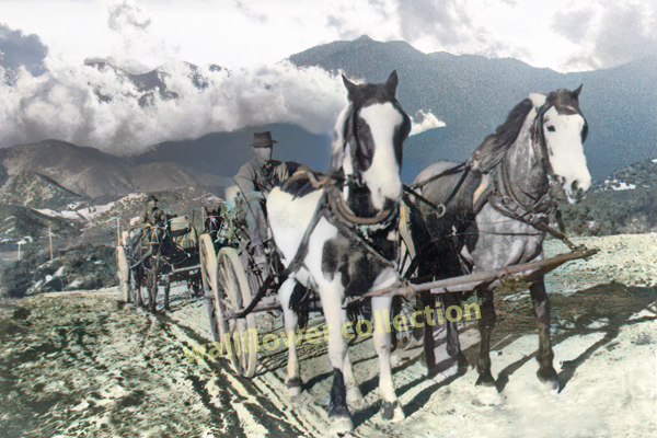
Freight ascends the Cajon Summit on the way to Hodge along the Mojave River - photo courtesy mojave river valley museum
Ascending Cajon Summit
Mojave River Valley Museum

Mining camps were established in the desert as early as 1850, with the beginning of gold mining at Salt Creek in the Amargosa Desert. Mining activities in other desert areas along the Colorado River and in the Sierra Nevada Mountains were running full steam in the 1860's. Stage and wagon roads soon were developed to link these remote areas to one another and to supply bases. Small settlements grew up at watering stops used by people and animals. Major routes soon received the attention of county road departments as the different coastal communities vied with each other for the financial benefits of the traffic to the mines.
:

Ranching began early in the better watered areas along the Mojave River, in the foothills of the Sierras and in the isolated remote valleys along the Colorado River. The ranches were vital sources of supply to mining and military camps located at great distances from coastal supply ports. Wagon roads and pack trails were developed to connect these isolated communities with one another.

Construction of the railroad through the desert in 1876-77 caused changes in the orientation of early wagon roads. Old mining camps as well as new ones linked up with the trains and exchanged their bullion and ores for food and machinery at spots once far from coastal sources of supply.

It was no longer necessary to move freight all the way to Visalia or Los Angeles or San Bernardino by the slowmoving freight wagons of earlier days. The railroad tracks provided new "jump-off" spots to explore and develop the remote desert interior. The developing network of cross-desert wagon roads changed after 1876 to reflect the availability of this rapid transportation.


Adapted from
Cultural Resources of the California Desert, 1776 -1880 -- Historic Trails and Wagon Roads
Elizabeth von Till Warren & Ralph J. Roske
1981 cultural
Russell L. Kaldenberg, Series Editor

Mojave River Route

Cajon Pass

Sanford Pass

Mojave River

North Fork

Salt Lake Road

Cut-offs

On the 1860 map of Lt. Davis (Casebier 1972) a "New" Salt Lake Road is drawn from Blake's Camp northward along the west side of the Cronese Mountains toward Soda Mountains,rejoining the older Salt Lake Trail at Bitter Springs. This "new" road is not recorded except on the Davis map of 1860 which Casebier reproduced for his 1972 publication. It is not known what the purpose of the "new" Salt Lake Trail was, unless it was for military operations of the period.

Kingston Cut-Off

Cox's Cut-Off

El Dorado Canon Cut-Off

Stoddard Well Road

San Bernardino-Panamint Road

The remaining major wagon roads and trails of the period in the Mohave Desert began as north- south trending roads linking Los Angeles and the gold fields to the north: Coso Range, Panamint Range, Owens Valley, and the Comstock mines of Nevada. These important lines of communication were also opened up because of the transcontinental railroad completed in 1869. New roads opened up subsequent to its completion to provide an outlet for the interior valleys via stage and wagon connections with train stations (Rossiter 1871, p. 17) . The earliest and most important road was the Los Angeles-Owens Valley road. Manly called it the "Big Owens Lake Trail" on his reminiscent map of his 1849 adventures (Wheat II, opp. p. 106) . Rossiter called it the Owens River Road.

Owens River Road

Cerro Gordo Mines Road

Coso Mines Road

Slate Range Roads

Walker Pass

Tehachapi Pass, Tehachapi Range

Tejon Pass Road

Panamint Pack Trail

Los Angeles-Panamint Road

Ivanpah - Providence

Search for a Southern Route

Freight

Intro:: Nature:: Map:: Parks:: Points of Interest:: Ghosts & Gold:: Communities:: Roads & Trails:: People & History:: Weather:: :?:: glossary
Country Life Realty
Wrightwood, Ca.
Mountain Hardware
Wrightwood, Ca.
Canyon Cartography
DesertLink
Links to Desert Museums

Grizzly Cafe
Family Dining

Custom Search

Abraxas Engineering
privacy
These items are historical in scope and are intended for educational purposes only; they are not meant as an aid for travel planning.
Copyright ©Walter Feller. 1995-2024 - All rights reserved.
4198