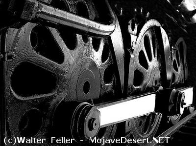
Railroad History in the Mojave Preserve
Railroads transformed the United States throughout the nineteenth century, prompting development of industry throughout
the country and providing conduits for development along their lines. The Mojave desert was in the path for one of the
earliest potential locations for the transcontinental railroad, the so-called
"35th Parallel Route"
or southern route explored by
Lieutenant A.W. Whipple
in 1854. If chosen for the transcontinental railroad, the 35th Parallel Route would
have placed the railroad through the South and given an economic boost to the slave-owning states of pre-Civil War
America. Ultimately, the decision of which of three routes to choose for a railroad to the Pacific was shelved because of
sectional politics, but within half a century the eastern Mojave desert was crossed by two transcontinental railroads as
well as a regional line.
Desert geography and competition between railroad companies dictated placement of the first railroad south of the
cross-desert
Mojave Road. In most
parts of the United States, railroads generally followed existing routes of travel,
since they were usually the paths of least geographical resistance, and A.W. Whipple followed the Mojave Road in his
1854 explorations. In the desert, the steepness of the terrain was of less concern to early travelers than the availability
of water. As a consequence, the Mojave Road, like the Indian trails it overlaid, traveled through mountain ranges rather
than around them. This feature made the track of the Mojave Road unsuitable for railroad use and created another pattern
of transportation across the eastern desert. A more moderately graded route was located in 1868 by General William J. Palmer,
working for the Union Pacific Railway, Eastern Division. [40] That railroad was never built, but the Southern Pacific
constructed a line through the desert in 1882-83, from
Mojave
to
Needles,
largely along Palmer's route. This road was built to forestall competition from the
Atlantic and Pacific Railroad (A&P),
which was controlled by the
Atchison, Topeka, and Santa Fe Railway, more casually known as the Santa Fe. The A&P reached the eastern bank of the
Colorado River
in May 1883, and the lines were connected three months later, but the Southern Pacific's control of the track
through the Mojave precluded its usefulness to the A&P. In 1884, after the Santa Fe threatened to build a line parallel to the
Southern Pacific's
route in order to allow traffic to pass, the latter railroad sold its desert trackage to the A&P. Although
the Santa Fe held control of the A&P since before its construction through the Mojave, the A&P name was used along the line
until 1897. Today the line, run by the
Burlington Northern and Santa Fe Railway,
forms much of the park's southern boundary. [41]
In addition to the trans-desert route of the Santa Fe, entrepreneurs constructed shorter railroads to directly service
settlements in the eastern Mojave. In 1893, the Nevada Southern Railway was constructed north from Goffs to Manvel, later
known as Barnwell, to tap into the mining districts of Southeastern California and Southern Nevada. It promptly went bankrupt,
and was reorganized in 1895 as the
California Eastern Railway. Six
years later, the line was extended into the Ivanpah Valley,
and in 1902 was taken over by the Santa Fe Railway. Four years later, the
Barnwell and Searchlight Railway
was built from Barnwell
to the mines at
Searchlight, Nevada. After
1918, the
Santa Fe
abandoned part of its line
in the Ivanpah Valley and only ran
trains past Barnwell as demand warranted. Several substantial washouts, combined with the unprofitability of the lines, caused
the Santa Fe to abandon all of its lines north of
Goffs
in 1923. [42] Lanfair/Ivanpah Road parallels the former Nevada Southern Railway
grade as it proceeds northward from Goffs, then runs directly upon it for part of the distance through the New York Mountains. Sometimes
the railroad grade can be seen from Ivanpah/Lanfair Road, washed out in several places. The grade of the line to
Searchlight
composes
much of the road that leads out of the park to the east, toward the Walking Box Ranch.
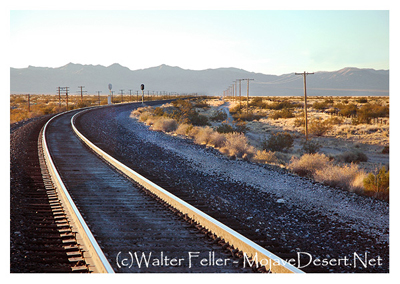
A second transcontinental railroad crossed the eastern Mojave shortly after the beginning of the twentieth century, and runs through
the middle of
Mojave National Preserve
today. In 1905, Senator William A. Clark of Montana, a mining magnate, built the
San Pedro, Los Angeles & Salt Lake Railroad
from
Salt Lake City southward across Utah, through southern Nevada, and across the Mojave desert to its Pacific Ocean terminus outside of
Los Angeles. The
Union Pacific Railroad (UP)
owned half of Clark's line, an agreement reached in settlement of a building race between
the two to complete the original road. In 1921, the Union Pacific took full control of the line, and it built the
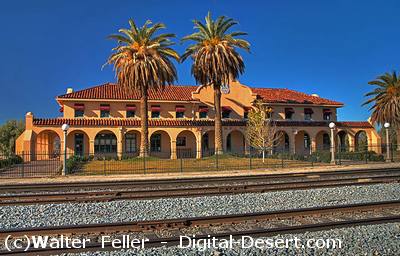
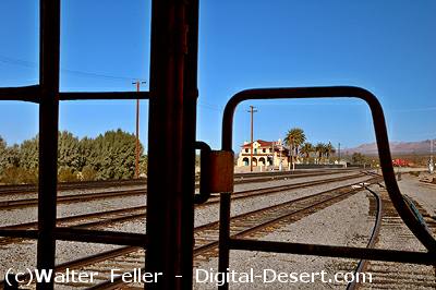
Kelso Depot
in 1924. Clark's railroad was responsible for many of the townsites in the heart of the Preserve, including
Kelso,
Cima, and
Nipton. The
UP line met the Santa Fe branch at Leastalk, later known as South Ivanpah and simply Ivanpah. The railroad,
though not as busy as the Burlington Northern Santa Fe route to the south, remains today a major transcontinental route. [43]
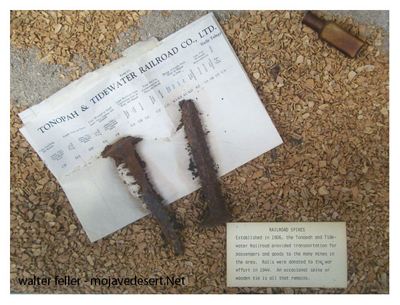
The
Tonopah & Tidewater Railroad,
known colloquially as the "T&T," was built by Francis Marion "Borax" Smith in 1906-1907 to tap his
borax mines near
Death Valley
and the silver and gold mines of central Nevada. The line never did reach the coast or Tonopah,
stopping just short of
Beatty, Nevada,
but served as the "neighborhood railroad" for much of the desert, and passed along the western boundary of the Preserve. [44] The
line was consistently unprofitable, and after ceasing operation in 1940, the rails were taken up for scrap metal during World War II.
The Tonopah & Tidewater crossed the Union Pacific at Crucero, at the extreme western tip of the Preserve; the railroad berm is still
in place in some areas, but the park boundary is just to the east, excluding that resource from the park, except where it crosses
the northwest portion of
Soda Lake
between Soda Station and
Baker. Soda Lake
was a siding on the Tonopah & Tidewater prior to its development as
Zzyzx. [45]
Railroads provided people with a means to live in the desert. Most of the human activity in historic times in the eastern Mojave
was related to the railroad, either as a means of transportation of Mojave goods to distant markets, as a means of bringing distant
goods to Mojave customers, or as a source of local employment, working for the railroads themselves. Most of the existing communities
near or inside the Preserve are legacies of the railroad. Goffs, Fenner, Essex,
Needles, and
Barstow were all started by the Atlantic
& Pacific, later the Santa Fe, while Las Vegas, Nipton, Cima, and Kelso were founded by the Union Pacific. Of nearby communities,
only Baker, which was merely a siding on the Tonopah & Tidewater, grew to importance solely during the later highway era. The more
than century-long importance of railroading in the development of the east Mojave was reflected in the California Desert Protection
Act's explicit reference to the "railroading history of the Old West." [46]
Source - NPS
Also see:
Railroads around the Mojave National Preserve