Subsection 322Am
Piute Valley - Sacramento Mountains

Chemehuevi Mountains Wilderness
This subsection includes Piute Valley, Dead Mountains, upper part of Ward Valley, Sacramento Mountains, Chemehuevi Valley, Whipple Mountains, and Turtle Mountains. The subsection is about half upland and half alluvial plain. It has a hot to very hot arid climate that is moderated by elevation on the higher mountains. MLRAs 29f and 30g.
Lithology and Stratigraphy. The uplands in this subsection are mainly Mesozoic granitic, Tertiary volcanic, and Precambrian granitic and metamorphic rocks. The alluvial plains are mostly Quaternary fluvial deposits, but some Pliocene and possibly earlier nonmarine Tertiary deposits. There are small areas of lacustrine deposits.
Geomorphology. This subsection is on steep to very steep mountains, gently to moderately sloping pediments and alluvial fans, and nearly level basin floor. Tertiary sediments are generally eroded to “badlands”. Dead Mountain, Piute Valley, and Ward Valley are aligned north-south. Sacramento Mountains and Turtle Mountains are oriented toward the northwest, but the Turtle Mountains are turned toward the north at the northern end, parallel to Ward Valley. Whipple Mountains and Chemehuevi Valley arc from a east-northeast trend around to a northwest trend parallel to and between the Turtle and Sacramento Mountains. The elevation range is from 450 feet along the Colorado River to about 3000 feet in the Sacramento Mountains, about 4000 feet in the Whipple Mountains, and up to 5866 feet on Horn Peak in the Turtle Mountains. Mass wasting and fluvial erosion and deposition are the main geomorphic processes.
Soils. The upland soils are mostly Lithic Torriorthents and Lithic Camborthids, plus Lithic Haplargids on volcanic rocks. Soils on alluvial plains are mostly Typic Torriorthents and Typic Torripsamments on younger fans and Typic Camborthids and shallow Typic Paleorthids on older fans. The soils are well drained. Soil temperature regimes are thermic in mountains and hyperthermic on most of the alluvial plains, except in Piute Valley. Soil moisture regimes are aridic.
Vegetation. The predominant natural plant communities are Creosote bush series and Creosote bush - white bursage series. Black bush series occurs on higher mountain slopes. Current plant communities include Tamarisk series in riparian areas along the Colorado River.
- Characteristic series by lifeform include:
Grasslands: Big galleta series, Indian ricegrass series.
Shrublands: Black bush series, Brittlebrush series, Creosote bush series, Creosote bush - white bursage series, Desert-holly series, Scadscale series, Tamarisk series, Teddybear cholla series, White bursage series.
Surface Water. Runoff is rapid from mountains and alluvial fans and slow from basin-fill. Most of the runoff drains through Piute Wash, Chemehuevi Valley, or Vidal Valley to the Colorado River, but some drains through Ward Valley to Danby Lake. Streams are dry most of each year; water flows in few of them except following intense rain.
< previous - Mojave Desert - next >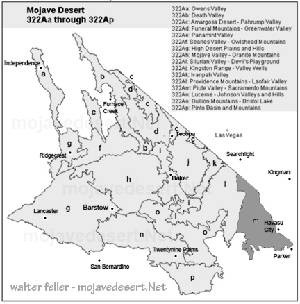
clickable map - select a section to view