Eastern Sierra & Death Valley SUV Route Guide
Route 1
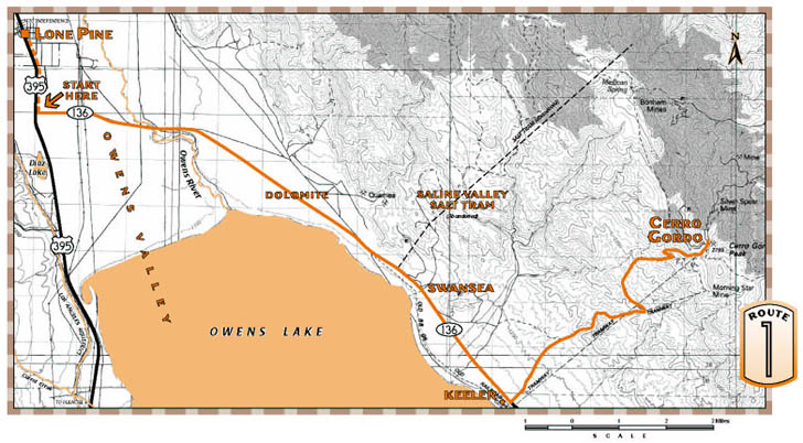
Cerro Gordo
The rich silver mines of Cerro Gordo, high in the Inyo Mountains, transformed the pueblo of Los Angeles into a busy center of commerce. This challenging and rewarding route follows the path of ore and supplies as it brings you to breathtaking heights.What to expect: The road is graded but quite rough. In the last 2 1/2 miles it climbs in a series of steep switchbacks with dizzying drop-offs and nowhere to turn around. Take your timedont overheat! Snow not cleared in winter. (Uphill vehicles have the right-of-way.)
Length: 21 miles.
Driving time: about 2 hours, one way.
Getting there: From Lone Pine, starting at the traffic light in the center of town, go 1.8 miles south on U.S. 395 and turn left (east) onto State Highway 136 at the Interagency Visitor Center. The route begins here. Along the route: Highway 136 leads toward the mountain range at the east side of the valley. In the 1860s, when local mining district superintendents asked native Paiute leader Chief George the mountains name, he is said to have replied Inyomeaning dwelling place of a great spirit.
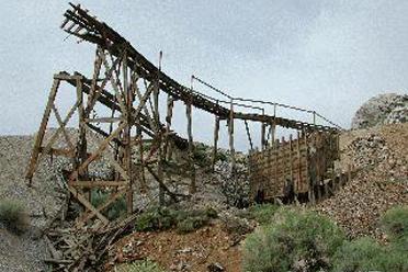
The river youll cross was called Wakopi by the Paiutes, and it filled the lake they called Pacheta. Explorer John C. Fremont in 1845 named river, lake and valley for his friend and expedition member Richard Owens. At that time Owens Lake had a surface area of 110 square miles. miles but was extremely shallow and saline. During the 1870s two steamers hauled silver bullion from smelters on the northeast shore to freight wagons waiting on the western shore, and on their return trip brought charcoal for the smelter fires.
Five miles along the route you can see, on the hillside, the white tailings of the Dolomite Mine. In the early 1890s local people called this site Mountain of Marble and sculptors and architects prized the pure white stone. A vein of equally high-quality black marble is just a few hundred yards away.
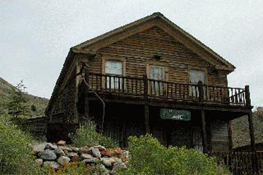
At 8.5 miles, as the road bends southward around the lake, look toward the foot of the mountains to see the concrete base of an historic salt tram that carried salt across the Inyos from Saline Valley on the other side. Up on the mountainside is one of the wooden tram towers.
The route encounters two small communities: Swansea, named for a Welsh coastal town, was the site of a furnace built in 1869 for processing Cerro Gordo ore. Keeler was named for a mine operator, responsible for laying out the town. Keeler was the southern terminus of the Carson & Colorado narrow-gauge railroad. The railroad never did link Carson City with the Colorado River as its named promised: by the time it reached Keeler in 1883, most of the local mines had played out.
Half a mile past Keeler, at 14.7 miles, turn left to read a historical plaque on a low rock, then head up the graded dirt Cerro Gordo Road. The road soon winds into the Inyo Mountains, up a rocky canyon where limestone laid down as ancient sea beds has been twisted and tilted by seismic forces. Youll pass the towers of an ore tram just as the road turns sharply north to begin its steep switchback climb to Cerro Gordo town site. As you climb, spiny, oddly-shaped Joshua trees begin to appear.
In 1865 Pablo Flores struck paydirt at Fat Hill and by 1871 Cerro Gordo was a well established mining town. The silver boom ended in 1878 but zinc revived the mines from 1911 to 1915. By then Cerro Gordo had produced some $15 million worth of ore, more than any other source of silver, lead and zinc in California.
Source - BLM
The Story of Inyo: Cerro Gordo
1862: The Rise & Fall of Cerro Gordo
Cerro Gordo Slideshow
click to zoom in