| Digital-Desert : Mojave Desert |
>>> Route 66 <<< From the Heartland to the Coast |
Photography by Walter Feller |
| features - ecology: wildlife - plants - geography: places - region map - map/sat - roads & trails: route 66 - video - aerial - 360 photos - old west - communities - lodging |
| ghost towns - gold mines - parks & ...: joshua tree - death valley - mojave preserve - wilderness - native culture - history - geology: natural features - glossary - comments |
|
|
Wilderness - MAP 
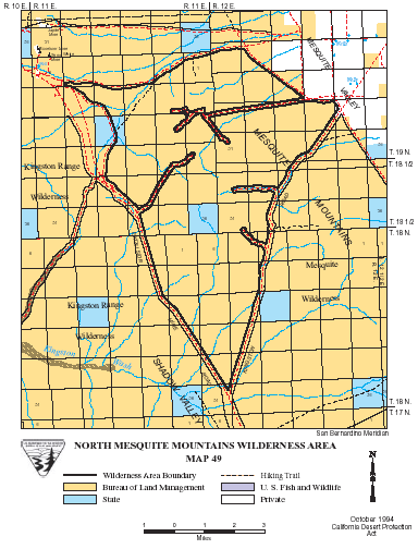
North Mesquite Range >> Map #49 North Mesquite Mountains Wilderness SIZE: 25,540 acres LOCATION: San Bernardino County; 60 miles northeast of Baker, California NATURAL RESOURCES: Rolling, brown foothills interspersed with a few steeper mountains comprise the north half of the Mesquite Mountains. A wide horseshoe shaped valley skirts these mountains on the west side of the wilderness. Joshua tree woodlands, yucca, cactus, blackbrush and grasses grow within the region, providing habitat for desert wildlife.
ACCESS: To access the southernmost point of the wilderness, take the Cima Road exit off Interstate 15 (26 miles east of Baker), and travel north approximately 8 miles on the paved Excelsior Mine Road until it intersects with the graveled Kingston Road. The wilderness lies between these two roads. |
|
| features - ecology: wildlife - plants - geography: places - region map - map/sat - roads & trails: route 66 - video - aerial - 360 photos - old west - communities - lodging |
| ghost towns - gold mines - parks & ...: joshua tree - death valley - mojave preserve - wilderness - native culture - history - geology: natural features - glossary - comments |
|
Country Life Realty Mountain Homes and Real Estate for Sale |
~ Wickless Candles by Scentsy ~ The Most Wonderful Time of the Year ... ... Is here |
MH Sleds Saucer sleds for the snow Life time guarantee!!! |
|
Abraxas Engineering privacy |
Copyright ©Walter Feller. All rights reserved. |