Eastern Sierra & Death Valley SUV Route Guide
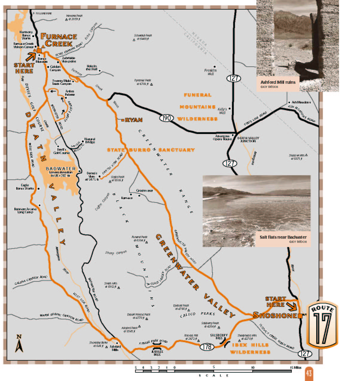
Route 17
Furnace Creek/ Greenwater Valley & West Side Road
This is the route for you if you want to see Death Valley off the beaten track, spending most of your time on dirt roads, taking in some of the most popular sights and some of the most hidden and obscure. You can do it all in one long day or make two routes of it, starting either at Furnace Creek or ShoshoneWhat to expect: About 2/3 is on dirt roads. Caution is advised in summer: extreme heat makes the danger of breaking down on a remote road truly life-threatening. Road conditions vary; get current information at the ranger stations, or by calling 760-786-2331. Intersections are well-marked.
Length: about a 135 mile loop, depending on side trips.
Driving time: four to five hours.
Getting there: The Death Valley National Park Visitor Center, on Highway 190 in Death Valley, is the start of the route. Or begin at Shoshone, just south of the intersection of Highways 127 and 178 east of Death Valley National Park.
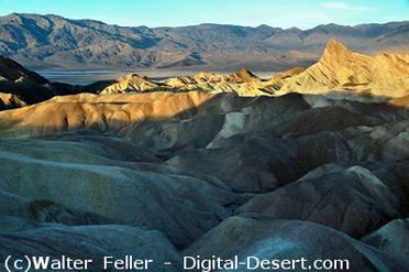
Along the route: The visitor center at Furnace Creek is a must; stop in again at the end of your trip to learn more about what youve seen. From there go 4 miles southeast along Highway 190 to Zabriskie Point for an incredible panoramic view over a maze of colorful hills. About a mile further along 190 is the entrance to Twenty Mule Team Canyon. This one-way dirt road winds nearly three miles through terrain similar to the badlands below Zabriskie Point. The many short tunnels in these hills are borax prospects.
Soon after rejoining 190, turn south onto the paved road to Dantes View. East are the privately owned Billie Mine and town of Ryan, existing because of borax, the white gold of the desert. Ascend steeply to Dantes View at the crest of the Black Mountains to look nearly 6,000 feet down onto your course for the second half of this route. The rugged Panamint Mountains rise to the west, and the Sierra Nevada can be seen beyond on clear days.
Back at the bottom, the unpaved road diverges south through Greenwater Valley. This valley is blanketed by recent basalt lava flows that create a relatively gentle topography. Much is above 3,000 feet, so the ecology is very different from that of Death Valley. Desert tortoises live here; their existence is threatened by habitat loss elsewhere, so its vital that vehicles stay on established roads. The valley is named for the vanished town of Greenwater, established in 1906 and soon boasting a population of 1,000. Hundreds of thousands of dollars were poured into developing what was described as the Greatest Copper Camp on Earth, with just one problem: there was very little copper. By December 1907 the town was abandoned. The road returns to the pavement of Highway 178 about eight miles from Shoshone. Drive east to Highway 127, then south to Shoshone for a refreshing break or to spend the night.
Return to Highway 178 and head east over Salsberry Pass, with superb views of the geologically complex southern end of Death Valley. Soon after turning north on the valley floor the road passes the ruins of Ashford Mill, built in 1914 to process gold ore from the mountains to the east. To the west, Shoreline Butte tells the story of a lake that filled Death Valley during the Ice Age, whose waves etched more than a dozen horizontal terraces along the buttes northeast flank. Imagine a time 150,000 years ago when Shoreline Butte was an island in a lake nearly 100 miles long and 600 feet deep!
Take the West Side Road which turns off to the left within 3 miles of Ashford Mill. This dirt road is entirely below sea level as it skirts the Panamint Mountains. North along the road is Bennetts Well, where two families nearly perished in 1850, waiting a month until two party members returned with supplies and knowledge of a route over the Panamints. Three miles north is the site of the Eagle Borax Works, where in the 1880s fifty men with high hopes scraped borax from the valley floor. When their hopes turned to despair the bankrupt owner killed himself. Less than a mile north are the graves of Shorty Harris and Jim Dayton. Shorty, one of Death Valleys colorful characters, asked to be buried beside his friend in the valley they loved. He wrote his own epitaph: Here lies Shorty Harris, a single-blanket jackass prospector.
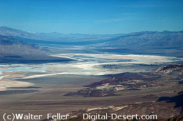
The route crosses vast salt pans and rejoins the paved Badwater Road. A short backtrack south (right) along this road allows you to take the colorful one-way Artists Palette loop. To the north the route passes the popular Golden Canyon hiking trail, then rejoins Highway 190 at Furnace Creek.
Source - BLM
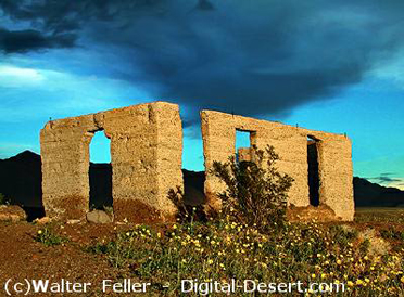
Ashford Mill
zoom in
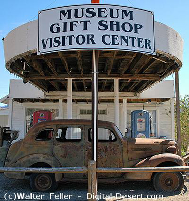
Shoshone Museum
Dante's View
Zabriskie Point